

On the afternoon of August 25, sharing with the press, Mr. Nguyen Van Huong (Head of Weather Forecast Department, National Center for Hydro-Meteorological Forecasting) said that at 3:00 p.m. on August 25, the storm center was at about 18.4 degrees North latitude, 106.1 degrees East longitude.
"By monitoring satellites, radars and enhanced monitoring stations, we have determined that the storm's eye has not yet completely made landfall. Currently, only about one-third is on land, while the remaining two-thirds are still at sea," said Mr. Huong.
In the next 1-3 hours, the storm will continue to move in a West-Northwest direction, entering the border area between Southern Nghe An and Northern Ha Tinh , with a strong intensity of level 11-12, gusting to level 14-15. After that, the storm will move to Central and Upper Laos, weaken into a tropical depression, then a low pressure area and gradually dissipate.
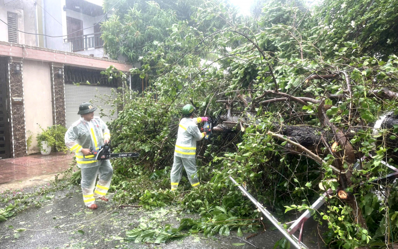
Thanh Sen Ward Police, Ha Tinh Province, cleared fallen trees during storm No. 5 to ensure safety and smooth traffic.
It is forecasted that this afternoon and tonight, the area from Southern Nghe An to Northern Ha Tinh will have strong winds of level 11-12, gusting to level 14. Neighboring areas such as Northern Nghe An, Thanh Hoa and Northern Quang Tri will also have strong winds of level 8-9, especially near the storm center, it can reach level 10-12, gusting to 14-15. Waves will be 5-7 meters high.
According to Mr. Huong, the risk of natural disasters is very high at this time. First of all, there are strong storms, so people in the southern Nghe An and northern Ha Tinh areas must be especially vigilant. Second, there is heavy rain, which is forecasted to occur from this evening and tonight until tomorrow morning (August 26), in the area from Thanh Hoa to Quang Tri , there will be very heavy rain, with rainfall ranging from 150-300 mm, and in some places over 500 mm. This increases the risk of flash floods and landslides in the western mountainous areas and flooding in low-lying areas.
"In coastal areas, when the storm center enters, there will be a temporary lull in the wind. But people should not be subjective, because then the wind changes direction, and the intensity is even stronger than when the storm first made landfall. People from Nghe An to Ha Tinh, Thanh Hoa and northern Quang Tri must pay special attention to this wind change phenomenon," Mr. Huong noted.
In addition, due to prolonged heavy rain, the risk of flash floods and landslides in the midland mountainous areas of Thanh Hoa, Nghe An, Ha Tinh and Quang Tri is very high. People need to be extremely vigilant, proactively evacuate, avoid crossing streams and ravines during heavy rain, and be on guard against flooding in low-lying areas.
Source: https://cand.com.vn/doi-song/khong-chu-quan-khi-thay-khoang-lang-gio-trong-thoi-diem-tam-bao-do-bo--i779263/


![[Photo] General Secretary To Lam attends the 80th anniversary of Vietnam's diplomacy](https://vphoto.vietnam.vn/thumb/1200x675/vietnam/resource/IMAGE/2025/8/25/3dc715efdbf74937b6fe8072bac5cb30)


Comment (0)