

Accordingly, from 1:00 p.m. on August 24, tourist boats, fishing vessels, and fishing boats are prohibited from going to sea. All activities of exploitation, aquaculture, fishing, and other activities in estuaries, coastal areas, and offshore are stopped.
Stop Dong Bai - Cai Vieng ferry, Cat Hai - Phu Long cable car; tourism and entertainment activities in sea and island areas from 3:00 p.m. on August 24.
The City Border Guard Command, the People's Committees of coastal communes and wards, and special zones regularly notify and call on ships operating at sea, workers working on aquaculture cages, watchtowers, etc. to take all measures to take shelter and safety. Arrange to avoid collisions and sinking of ships at anchorage. All of this work must be completed before 3:00 p.m. on August 24.
Resolutely prevent and do not allow fishing boats and inland waterway vehicles that have entered shelters to operate during times of strong winds and big waves.
The Hai Phong City Department of Construction's Inland Waterways Port Authority has issued an official dispatch to temporarily stop issuing entry and exit permits for watercraft operating at inland ports, wharves, and anchorage areas under its management from 1:00 p.m. on August 24.
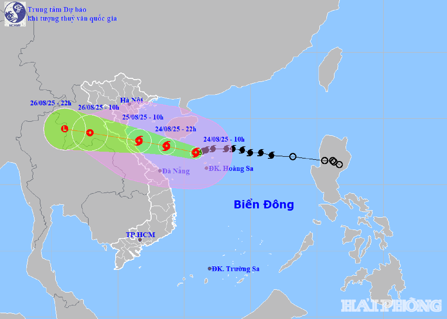
Storm level 12 - 13 heading towards Nghe An - Ha Tinh
According to the National Center for Hydro-Meteorological Forecasting, at 10:00 a.m. on August 24, the center of storm No. 5 was located at about 17.4 degrees north latitude, 110.9 degrees east longitude, in the northwest sea of Hoang Sa special zone, about 580 km from Nghe An, about 560 km east southeast of Ha Tinh. The strongest wind speed is level 12 - 13 (118-149 km/h), gusting to level 15. The storm is moving westward at a speed of about 20 km/h.
It is forecasted that in the next 24 - 60 hours, storm No. 5 will move west-northwest. At 10:00 p.m. on August 24, storm No. 5 will be at about 17.9 degrees north latitude, 108.7 degrees east longitude, 300 km from Nghe An and 270 km from Ha Tinh. The intensity is level 13-14, gusting to 16. The storm will continue to move west-northwest at a speed of 20 km/h.
Due to the influence of storm No. 5, from noon on August 24, the sea area of Thanh Hoa - Hue (Hon Ngu, Con Co) has winds of level 7 - 9, then increasing to 10 - 11, near the storm center 12 - 14, gusts 16; waves 5 - 7m, near the center 8 - 10m, very rough seas. On the afternoon of August 24, the North of Bac Bo Gulf (Cat Hai, Co To, Van Don) has winds of level 6 - 7, gusts 9; the South (Bach Long Vi) has winds of level 8 - 9, gusts 11; waves 2.5 - 4.5m, very rough seas. Provinces and cities from Hai Phong to North Quang Tri should be on guard against sea level rise of 0.5 - 1.5m. High risk of flooding in low-lying areas, coastal areas, and river mouths in the evening of August 25.
On land from the night of August 24, the provinces from Thanh Hoa - Quang Tri have winds of level 8 - 10, near the storm center 11 - 13, gusts 14 - 15. Coastal Quang Ninh - Ninh Binh: winds of level 6 - 8, gusts 9. From August 24 - 26, the provinces of the Northern Delta, South Phu Tho, Thanh Hoa - Hue city have rain from 100 - 150mm, some places >250mm. Thanh Hoa - North Quang Tri from 200 - 400mm, some places >700mm.
Source: https://baohaiphong.vn/hai-phong-cam-bien-tu-13-gio-ngay-24-8-518977.html
![[Photo] Red flag with yellow star flutters in France on National Day September 2](https://vphoto.vietnam.vn/thumb/1200x675/vietnam/resource/IMAGE/2025/8/28/f6fc12215220488bb859230b86b9cc12)
![[Photo] General Secretary To Lam attends the opening ceremony of the National Achievements Exhibition](https://vphoto.vietnam.vn/thumb/1200x675/vietnam/resource/IMAGE/2025/8/28/d371751d37634474bb3d91c6f701be7f)
![[Photo] Politburo works with the Standing Committee of Cao Bang Provincial Party Committee and Hue City Party Committee](https://vphoto.vietnam.vn/thumb/1200x675/vietnam/resource/IMAGE/2025/8/28/fee8a847b1ff45188749eb0299c512b2)
![[Photo] Prime Minister Pham Minh Chinh meets with Speaker of the New Zealand Parliament Gerry Brownlee](https://vphoto.vietnam.vn/thumb/1200x675/vietnam/resource/IMAGE/2025/8/28/cec2630220ec49efbb04030e664995db)

![[Photo] General Secretary To Lam presents the 45-year Party membership badge to comrade Phan Dinh Trac](https://vphoto.vietnam.vn/thumb/1200x675/vietnam/resource/IMAGE/2025/8/28/e2f08c400e504e38ac694bc6142ac331)


Comment (0)