

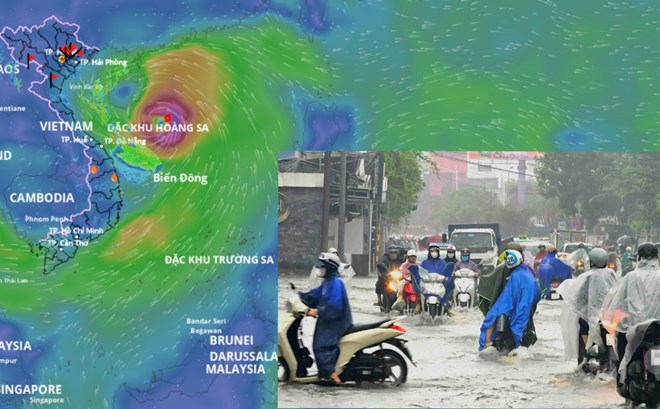
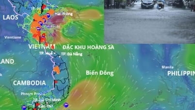
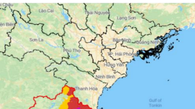
Storm No. 5 is forecast to cause widespread heavy rain from tonight, August 24. Storm location source: Vietnam Disaster Monitoring System
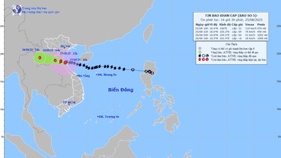
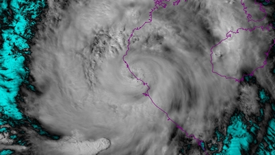
Latest update from the National Center for Hydro-Meteorological Forecasting, at 4:00 a.m. on August 24, the center of storm No. 5 was located at approximately 17.6 degrees north latitude; 111.7 degrees east longitude, approximately 660 km east-southeast of Nghe An, approximately 640 km east of Ha Tinh . The strongest wind near the center of the storm is level 12 (118 - 133 km/h), gusting to level 15.

Mr. Mai Van Khiem - Director of the National Center for Hydro-Meteorological Forecasting analyzed storm number 5.
Storm No. 5 can gust up to level 16
According to Mr. Mai Van Khiem - Director of the National Center for Hydro-Meteorological Forecasting, in the next 24 hours, the storm is forecast to move west-northwest at a speed of about 20 km/hour.
At 4:00 a.m. on August 25, the center of the storm was at about 18.3 degrees north latitude; 107.8 degrees east longitude, in the southern part of the Gulf of Tonkin, about 230 km from Nghe An , about 210 km east of Ha Tinh. Winds were at level 12-13, gusting to level 15 and could continue to strengthen.
"We assess that this is a relatively special storm, formed right in the East Sea, with very strong intensity, moving quickly and having a very wide range of impact. According to forecasts from the Vietnam Meteorological Agency as well as international assessments, this storm number 5 is likely to reach level 12, 13 intensity, gusting to level 15, 16. In particular, there are models showing a more extreme and stronger level when moving closer to the coastal waters of our country" - Mr. Khiem analyzed.
It is forecasted that in the next 48 hours, the storm will move west-northwest at a speed of 15-20 km/hour and gradually weaken into a tropical depression.
At 4:00 a.m. on August 26, the center of the tropical depression was at about 18.8 degrees north latitude; 103.7 degrees east longitude, over the upper Laos region. Winds were at level 6-7, gusting to level 9. Dangerous areas were from 16 to 20 degrees north latitude; west of the 108.5 degrees east longitude.
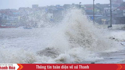
Impact on mainland causing heavy rain and strong winds from tonight 24.8
Regarding the impact at sea, according to Mr. Khiem, the sea area west of the northern East Sea (including Hoang Sa special zone) has strong winds of level 8 - 10, the area near the storm's eye has winds of level 11 - 13, gusting to level 15; waves are 5 - 7 m high, the area near the storm's eye is 7 - 9 m, the sea is very rough.
From noon and afternoon of August 24, the sea area from Thanh Hoa to Thua Thien Hue (including Hon Ngu island, Con Co special zone) will have winds gradually increasing to level 6 - 8, then increasing to level 9 - 10, the area near the storm's center will have winds of level 11 - 13, gusting to level 15; waves 4 - 6 m high, the area near the center 7 - 9 m, the sea is very rough.
From the afternoon of August 24, the northern part of the Gulf of Tonkin (including Cat Hai, Co To, and Van Don special economic zones) will have winds gradually increasing to level 6-7, gusting to level 9; the southern part of the Gulf of Tonkin (including Bach Long Vi special economic zone) will have strong winds of level 8, gusting to level 10, waves 2-4 m high, and rough seas.
Coastal areas from Ninh Binh to northern Quang Tri have storm surges of 0.5 - 1.5 m. Water levels at Sam Son (Thanh Hoa) are 3.3 - 3.8 m high, at Hon Ngu (Nghe An) are 3.5 - 4 m high, at Vung Ang (Ha Tinh) are 2.5 - 3 m high and at Cua Gianh (Quang Tri) are 1.5 - 2 m high.
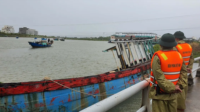
High risk of flooding in low-lying coastal areas, river mouths, and islands from Thanh Hoa to northern Quang Tri.
The meteorological agency also warned that the weather at sea and in coastal areas during the storm is extremely dangerous and unsafe for all types of vehicles and structures such as cruise ships, passenger ships, transport ships, cages, aquaculture areas, dykes, and coastal roads. Vehicles are highly likely to capsize, be destroyed, or be flooded due to strong winds, large waves, and rising sea levels.
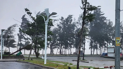
On land, from the night of August 24, the provinces from Thanh Hoa to Quang Tri will have winds gradually increasing to level 7 - 9, near the storm center level 10 - 12, gusting to level 14 - 15; coastal areas from Quang Ninh to Ninh Binh will have winds gradually increasing to level 6 - 7, gusting to level 8.
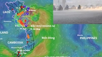
From the night of August 24 to the end of August 26, in the Northern Delta region, southern Phu Tho and from Thanh Hoa to Thua Thien Hue, there is a possibility of widespread heavy rain.
"Rainfall is generally 100 - 150 mm, locally over 250 mm; in particular, the area from Thanh Hoa to northern Quang Tri will have heavy to very heavy rain with rainfall generally 200 - 400 mm, locally over 700 mm. There is a high risk of heavy rain over 200 mm in 3 hours" - Mr. Khiem warned.
The director of the meteorological agency added that from August 25 to 26, the capital Hanoi and Da Nang city will have moderate to heavy rain and thunderstorms; Ho Chi Minh City will have showers and thunderstorms in the late afternoon and evening. During thunderstorms, it is necessary to be on guard against the risk of tornadoes and strong gusts of wind.
From August 25 to 27, the upper and central regions of Laos will have heavy rain with common rainfall of 100 - 250 mm, with some places in central Laos having over 500 mm.
Laodong.vn
Source: https://laodong.vn/moi-truong/bao-so-5-giat-cap-15-tiep-tuc-manh-len-khi-sap-do-bo-du-bao-duong-di-24-gio-toi-1562518.ldo

![[Photo] General Secretary To Lam attends the 80th anniversary of Vietnam's diplomacy](https://vphoto.vietnam.vn/thumb/1200x675/vietnam/resource/IMAGE/2025/8/25/3dc715efdbf74937b6fe8072bac5cb30)


Comment (0)