

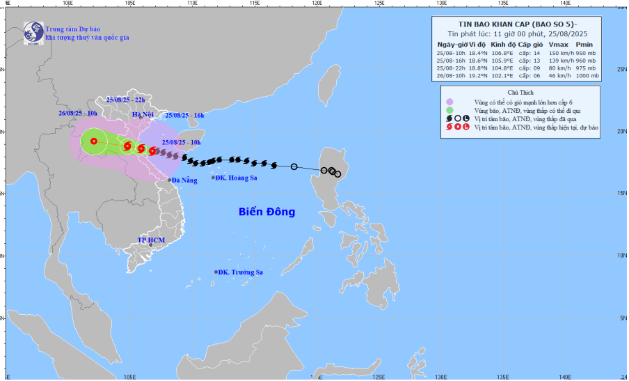
Forecast map of storm No. 5's trajectory and intensity released at 11:00 on August 25, 2025.
At 10:00 a.m. on August 25, the center of the storm was at approximately 18.4 degrees North latitude; 106.8 degrees East longitude, approximately 120 km East Southeast of Nghe An, approximately 100 km East of Ha Tinh , approximately 130 km East Northeast of Quang Tri. The strongest wind near the center of the storm was level 13-14 (134-166 km/h), gusting to level 17; moving West Northwest at a speed of 15-20 km/h.
It is forecasted that by 4:00 p.m. on August 25, storm No. 5 will move west-northwest at a speed of 15-20km/hour, with its center over the waters of Thanh Hoa to Ha Tinh provinces. The intensity is level 12-13, gusting to level 15.
At 10 p.m. on August 25, the storm made landfall in the provinces of Thanh Hoa to Ha Tinh, with intensity reduced to level 9, gusting to level 12.
At 10:00 a.m. on August 26, the storm moved in a West Northwest direction, at a speed of about 20km/h, gradually weakening into a tropical depression.
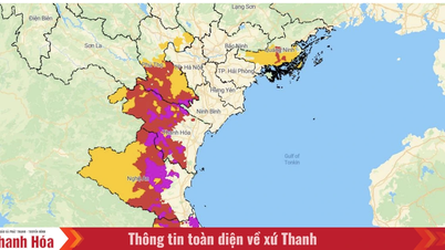
Due to the influence of storm No. 5, the sea area from Thanh Hoa to Quang Tri (including Hon Ngu island, Con Co special zone) has strong winds of level 8-11, near the storm's eye level 12-14, gusting to level 17; waves 5-7m high, near the storm's eye 8-10m; very rough seas. The northern part of Bac Bo Gulf (including the special zones: Cat Hai, Co To, Van Don) has strong winds of level 6-7, gusting to level 9; the southern part of the northern part of Bac Bo Gulf (including Bach Long Vi special zone) has strong winds of level 8-9, gusting to level 11; waves 3-5m high; very rough seas.
Storm surge and flood warning for coastal areas: Coastal areas and islands from Hai Phong to Northern Ha Tinh have storm surges of 0.5-1.8m, Thanh Hoa and Nghe An 1.0-1.8m in particular. Water levels at Hon Dau (Hai Phong) are 3.5-4.0m high, Ba Lat (Ninh Binh) 1.8-2.3m, Sam Son (Thanh Hoa) 3.7-4.2m, Hon Ngu (Nghe An) 3.5-4.0m, and Cua Nhuong (Ha Tinh) 2.2-2.6m. There is a high risk of flooding of dykes, coastal roads, and river mouths, especially in the coastal areas of Nghe An and Thanh Hoa in the afternoon and evening of August 25.
On land, in the North Thanh Hoa area, there will be strong winds of level 8-9, gusting to level 10-11; in the South Thanh Hoa-North Ha Tinh area, there will be strong winds of level 10-11, near the storm center, there will be level 12-13, gusting to level 15-16; in the South Ha Tinh, Quang Tri, and coastal areas of the provinces from Quang Ninh to Ninh Binh, there will be strong winds of level 6-8, gusting to level 9-10.
From noon on August 25 to the end of August 26, in the midlands and deltas of the North, Lao Cai, Son La and from Thanh Hoa to Quang Tri, there will be widespread heavy rain with common rainfall of 100-150mm, locally over 250mm; in the area from Thanh Hoa to Northern Quang Tri, there will be heavy to very heavy rain with common rainfall of 200-400mm, locally over 600mm. Warning of the risk of heavy rain (>200mm/3 hours).
LP
Source: https://baothanhhoa.vn/bao-so-5-di-chuyen-nhanh-du-bao-16-gio-chieu-nay-vao-toi-vung-bien-tu-thanh-hoa-den-ha-tinh-259401.htm


![[Photo] General Secretary To Lam attends the 80th anniversary of Vietnam's diplomacy](https://vphoto.vietnam.vn/thumb/1200x675/vietnam/resource/IMAGE/2025/8/25/3dc715efdbf74937b6fe8072bac5cb30)


Comment (0)