
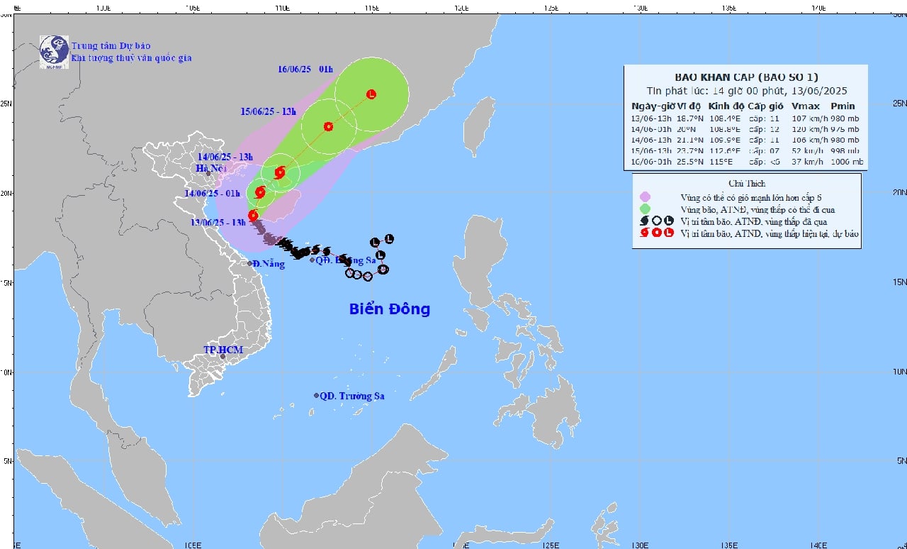
The recent storm No. 1 - Wutip was considered unusual when it appeared in mid-June.
Storm No. 1 is the first storm in the East Sea to appear in June after more than 40 years, and is also the first storm to cause especially heavy rain in the Central Central region in June since 1952.
Rainfall in Hue highest in history in June
Regarding the recent unusual heavy rain and flood disaster in the Central region, the National Center for Hydro-Meteorological Forecasting informed that the natural disaster from June 10-14, 2025 due to the influence of storm No. 1 (Wutip) was special, unusual and extreme in nature, rare in the history of hydro-meteorology in the Central region.
This is the first storm in the East Sea to appear in June after more than 40 years, and the first storm to cause exceptionally heavy rain in the Central Central region in June since 1952, with rainfall far exceeding previous records.
Very heavy to extremely heavy rain occurred widely from South Ha Tinh to Quang Nam , total rainfall was commonly 250-550mm, many places over 800mm, especially Bach Ma station (Hue) reached 1,203mm/3 days - the highest in history in June, surpassing the record of 410mm/1 day in Nam Dong in 1983.
More unusually, there were 32 stations recording 6-hour rain exceeding 200mm, of which Loc Tri station ( Thua Thien Hue ) recorded up to 319.4mm in 6 hours - an extreme level rarely seen in the June data series.
The storm circulation caused an early and unusual flood, concentrated from June 11-14 on rivers from South Quang Binh to Quang Nam, with flood peaks generally at alert levels 2-3, some rivers exceeding alert level 3: Thach Han (6.04m), Bo (4.50m) were both the highest flood peaks in June in the past 30 years.
“This natural disaster shows the seasonal shift and extreme level of weather and climate, which is unusual and no longer regular,” the National Center for Hydro-Meteorological Forecasting assessed.
Floods in Central Vietnam are historic and rare.
The flood from June 11-14 in rivers from South Quang Binh to Quang Nam was assessed as historic and rarely seen in the same period in the observation data series.
According to statistics, the flood peak on Kien Giang River at Kien Giang station, Thach Han River at Thach Han, Bo River at Phu Oc and Vu Gia River at Ai Nghia is the highest flood peak in the past 30 years. During this period of rain and flood, flooding and landslides occurred in many places in the provinces from Quang Binh to Quang Nam.
According to the National Center for Hydro-Meteorological Forecasting, regarding the forecasting and warning of the impact of storm No. 1, the Center issued bulletins very early.
Forecasts and warnings of strong winds at sea, big waves, rising sea levels combined with high tides and heavy rain are all updated fully, promptly and reliably.
The Center has provided timely and complete forecast and warning information to the National Steering Committee for Natural Disaster Prevention and Control, the National Committee for Incident and Disaster Response and Search and Rescue, and the Steering Committees for Natural Disaster Prevention and Control and Search and Rescue of ministries, branches and localities in the Central region provinces, news agencies and newspapers to transmit as soon as possible to local people, contributing to minimizing human and property damage.
The Center has issued 35 bulletins on storm No. 1, 17 flash bulletins; 15 bulletins on heavy rain and 13 rainfall forecast bulletins; 16 flash flood and landslide warning bulletins; 4 flood warning bulletins on rivers from Quang Binh to Quang Ngai, 3 flood warning bulletins and flood news on Huong River (Hue City).
In the news, there were warnings of the risk of flash floods, landslides, inundation and the impact of rain and floods.
According to anninhthudo.vn
Source: https://baothanhhoa.vn/bao-so-1-xuat-hien-vao-thang-6-hon-40-nam-moi-co-mot-lan-252449.htm


Comment (0)