
At noon on June 14, regarding the developments of storm No. 1, Dr. Hoang Phuc Lam, Deputy Director of the National Center for Hydro-Meteorological Forecasting, said that the storm continued to change direction, moving northeast at a speed of about 15km/h, in the eastern sea area of the northern Gulf of Tonkin.
Due to the influence of the storm circulation, in Bach Long Vi island district, there are strong winds of level 8, gusting to level 9; in Con Co island district (Quang Tri), there are strong winds of level 7, gusting to level 8; in Bai Chay, Cua Ong and Co To ( Quang Ninh ), there are strong winds of level 6, gusting to level 7.
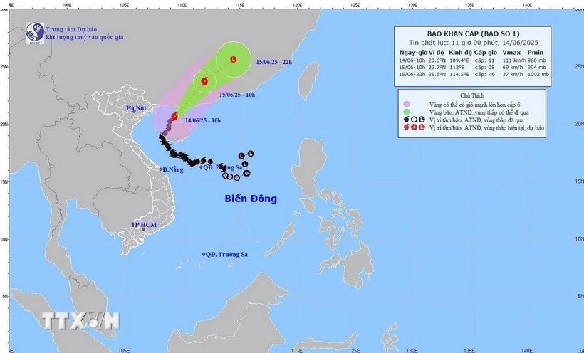
At 10:00 a.m. on June 14, the center of the storm was at about 20.6 degrees North latitude; 109.4 degrees East longitude, in the sea east of the northern Gulf of Tonkin, about 210km east-northeast of Bach Long Vi island.
The strongest wind near the storm center is level 10-11 (89-117km/h), gusting to level 13; moving northeast at a speed of about 15km/h.
Commenting specifically on the developments, Mr. Hoang Phuc Lam said that by 10:00 a.m. on June 15, the storm was moving northeast over the mainland of Guangdong province (China) at a speed of about 15-20 km/h and gradually weakening.
The storm's strongest wind is level 8, gusting to level 10. The dangerous area is the northern sea of the Gulf of Tonkin and the northwest of the northern East Sea. Disaster risk warning level 3.
At 10 p.m. on June 15, the storm moved northeastward over the mainland of Guangdong province (China) at a speed of about 20-25 km/h and gradually weakened into a tropical depression, then weakened into a low pressure area. Wind force below level 6.
Mr. Hoang Phuc Lam noted that due to the impact of the storm, the northern sea area of Bac Bo Gulf (including Co To and Bach Long Vi island districts) has strong winds of level 6-7, in the East strong winds of level 8-9, near the storm's eye level 10-11, gusts of level 13, waves 2-4m high, rough seas.
Northwest of the North East Sea area has strong winds of level 6, gusts of level 8, waves 2-4m high, rough seas.
Ships operating in the above mentioned dangerous areas are likely to be affected by storms, whirlwinds, strong winds and large waves.
On land, the coastal area of Quang Ninh - Hai Phong at noon on June 14 has strong winds of level 6, gusting to level 7-8.
According to VNA
Source: https://baothanhhoa.vn/bao-so-1-doi-huong-di-chuyen-theo-huong-dong-bac-voi-suc-gio-giat-cap-13-252140.htm


Comment (0)