


Low pressure area strengthens into tropical depression
According to the National Center for Hydro-Meteorological Forecasting, a low pressure area is currently operating in the eastern sea of the North East Sea .
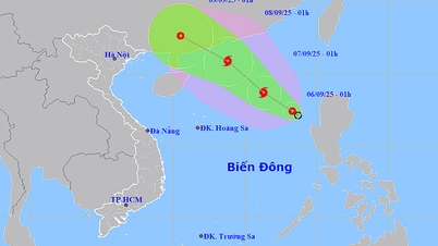
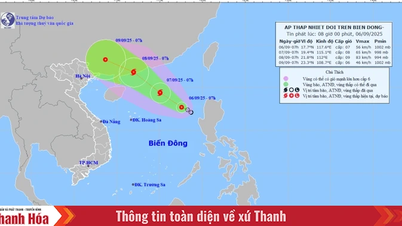
Tonight (September 5), the low pressure area in the northeastern part of the East Sea has strengthened into a tropical depression.
At 7:00 a.m. on September 6, the center of the tropical depression was at about 17.7°N - 117.6°E, in the northeastern part of the East Sea. The strongest wind was level 7 (50 - 61 km/h), gusting to level 9. Moving northwest at a speed of 10 - 15 km/h.
Tropical depression likely to strengthen into storm and continue to strengthen
Forecast of tropical depression/storm development (next 24 - 48 hours): By 7:00 a.m. on September 7, the tropical depression will move northwest at a speed of 10 - 15 km/h, with the potential to strengthen into a storm.
Forecast location is 19.4°N - 115.1°E, about 430 km northeast of Hoang Sa archipelago. Strong winds of level 8, gusting to level 10.
Danger zone: latitude 16.0 - 21.0°N; longitude 113.5 - 119.0°E. Disaster risk level: level 3, northeastern sea area of the East Sea.
At 7:00 a.m. on September 8, the storm continued to move northwest at a speed of about 15 km/h and strengthened.
Location at 21.8°N - 112.0°E, on the coast of Guangdong province (China). Strong wind level 9, gust level 11.
Dangerous area: North of latitude 18.0°N; longitude 110.0 - 117.0°E. Disaster risk level: level 3, sea area north of the East Sea.
Storm warning (next 48 - 72 hours)
In the next 48 - 72 hours, the storm will move in the West Northwest direction, at a speed of about 15 km/h.
Forecasting the impact of tropical depressions/storms
At sea: The northeastern sea area of the East Sea has strong winds of level 6, then increasing to level 7 - 8, gusting to level 10; waves 2.0 - 4.0 m high, rough seas.
Vessels operating in the danger zone are subject to storms, whirlwinds, strong winds and large waves.

Telegram on responding to tropical depression in the East Sea
To proactively respond to tropical depressions, the Minister of Agriculture and Environment issued Official Dispatch No. 6408/CD-BNNMT dated September 5, 2025 requesting ministries, branches and People's Committees of coastal provinces and cities from Quang Ninh to Dak Lak:
1. Closely monitor the development of tropical depressions; strictly manage means of transport going out to sea; organize counting and notify owners of means of transport, captains of ships and boats operating at sea of the location, direction of movement and development of tropical depressions to proactively avoid, escape or not move into dangerous areas.
2. Prepare forces and means for rescue when requested.
3. Vietnam Television, Voice of Vietnam, Vietnam News Agency , the coastal information station system and mass media agencies from central to local levels increase information on the developments of tropical depressions to authorities at all levels, owners of means of transport operating at sea and people to proactively prevent and respond.
4. Ministries and branches, according to their functions, state management tasks and assigned tasks, proactively direct and coordinate with localities to respond to tropical depressions.
5. Be on duty seriously and regularly report to the Ministry of Agriculture and Environment (through the Department of Dike Management and Disaster Prevention and Control).
Proactively respond to low pressure areas that are likely to strengthen into tropical depressions in the East Sea
On September 5, 2025, the Ministry of Agriculture and Environment issued Document No. 6385/BNNMT-DD dated September 5, 2025 on proactively responding to low pressure areas that are likely to strengthen into tropical depressions.
Document sent to People's Committees of coastal provinces and cities from Quang Ninh to Quang Ngai with the following content:
According to bulletin No. XTND-14h30/DBQG_DBTT dated September 5, 2025 of the National Center for Hydro-Meteorological Forecasting, a low pressure area is operating in the eastern sea of the North East Sea.
At 1:00 p.m. on September 5, the low pressure area was located at about 16.0 - 17.0 degrees North latitude, 117.8 - 118.8 degrees East longitude; it is forecasted that in the next 24 hours, the low pressure area will move in a West Northwest direction and is likely to strengthen into a tropical depression.
To proactively respond, the Ministry of Agriculture and Environment recommends that the People's Committees of provinces and cities:
1. Closely monitor warning bulletins, forecasts and developments of low pressure areas that are likely to strengthen into tropical depressions; notify captains and owners of vehicles and vessels operating at sea to proactively prevent and adjust production plans, ensure safety of people and property; maintain communication to promptly handle possible adverse situations.
2. Prepare forces and means to deploy rescue work when there is a situation.
3. Be on duty seriously and regularly report to the Ministry of Agriculture and Environment (through the Department of Dike Management and Disaster Prevention and Control).
Propose that the People's Committees of provinces and cities urgently implement.
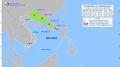
Low pressure causes wind gusts of level 9. Rough seas
Past status: On September 5, the tropical convergence zone with its axis passing through the North East Sea area connected to the low area in the eastern sea area of the North East Sea area.
At 13:00, the center of the low pressure area was at about 16.0 - 17.0 degrees North latitude; 117.8 - 118.8 degrees East longitude.
The eastern sea area of the North and Central East Sea, the southwestern sea area of the South East Sea has scattered showers and thunderstorms.
Forecast for the next 24 hours: On September 6, in the eastern sea area of the North East Sea, there will be strong winds of level 6, gusting to level 8. Rough seas, waves 2.0 - 4.0m high, in many directions.
In addition, on the night of September 5 and 6, the sea area from Lam Dong to Ca Mau, Ca Mau to An Giang, the Gulf of Thailand, the North East Sea, the Central and South East Sea (including the Hoang Sa and Truong Sa special zones) will have scattered showers and thunderstorms. During the thunderstorms, there is a possibility of tornadoes, strong gusts of wind of level 6 - 7 and waves over 2.0m high.
Warning: On the night of September 6 and September 7, in the northern sea area of the North East Sea, there will be strong winds of level 6 - 7, gusting to level 9. Rough seas, waves 2.0 - 4.0m high. Disaster risk level due to strong winds at sea: level 2.
Impact Forecast: All vessels operating in the above areas are at high risk of being affected by cyclones, strong winds and large waves.
Description of tropical depression/storm wind level and level of impact

Source: https://baolaocai.vn/ap-thap-nhiet-doi-tren-bien-dong-va-cac-chi-dao-ung-pho-post881425.html
![[Photo] Prime Minister Pham Minh Chinh attends the 80th Anniversary of the Vietnam Posts and Telecommunications Group](https://vphoto.vietnam.vn/thumb/1200x675/vietnam/resource/IMAGE/2025/9/6/39a89e5461774c2ca64c006d227c6a4e)
![[Photo] General Secretary To Lam attends the 80th Anniversary of the General Staff of the Vietnam People's Army](https://vphoto.vietnam.vn/thumb/1200x675/vietnam/resource/IMAGE/2025/9/6/126697ab3e904fd68a2a510323659767)
![[Photo] 80th Anniversary of the General Staff of the Vietnam People's Army](https://vphoto.vietnam.vn/thumb/1200x675/vietnam/resource/IMAGE/2025/9/6/49153e2a2ffc43b7b5b5396399b0c471)

![[Photo] Rescuing people in flooded areas at the foot of Prenn Pass overnight](https://vphoto.vietnam.vn/thumb/1200x675/vietnam/resource/IMAGE/2025/9/6/19095b01eb844de98c406cc135b2f96c)


![[Photo] Many people directly experience beloved Uncle Ho and the General Secretaries](https://vphoto.vietnam.vn/thumb/1200x675/vietnam/resource/IMAGE/2025/9/6/2f4d9a1c1ef14be3933dbef3cd5403f6)


Comment (0)