

.jpg)
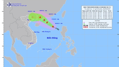
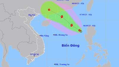
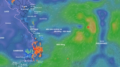
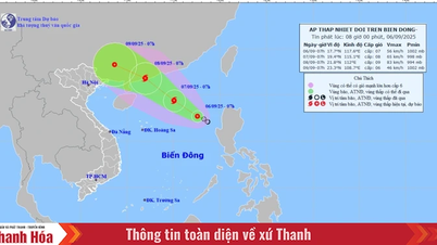
According to the National Center for Hydro-Meteorological Forecasting, on the evening of September 5, the low pressure area in the northeastern region of the East Sea strengthened into a tropical depression.
At 1:00 a.m. on September 6, the center of the tropical depression was at about 17.4 degrees North latitude; 118.3 degrees East longitude, in the sea area east of the North East Sea. The strongest wind near the center of the tropical depression was level 6 (39 - 49 km/h), gusting to level 8. Moving northwest, speed about 10 km/h.
It is forecasted that at 1:00 a.m. on September 7, the tropical depression will move northwest at a speed of about 10 km/h and is likely to strengthen into a storm. Thus, this will be the 7th storm in the East Sea during the 2025 rainy season.
At 7:00 p.m. on September 7, the storm center was located in the northern part of the North East Sea, with strong winds of level 9, gusts of level 11. The dangerous area is between latitude 17-22 degrees North; longitude 113-117.5 degrees East. Disaster risk level: level 3, northern East Sea.
During the next 48 to 72 hours, the storm will continue to move northwest at 10-15 km per hour.
Due to the influence of the tropical depression that later strengthened into a storm, the northeastern sea area of the East Sea had strong winds of level 6, later increasing to level 7-8, gusting to level 10; waves 2-4m high, rough seas. Ships operating in the above-mentioned dangerous areas are likely to be affected by storms, whirlwinds, strong winds and big waves.
PVSource: https://baohaiphong.vn/ap-thap-nhiet-doi-xuat-hien-tren-bien-dong-du-bao-manh-len-thanh-bao-so-7-520039.html
![[Photo] General Secretary To Lam attends the 80th Anniversary of the General Staff of the Vietnam People's Army](https://vphoto.vietnam.vn/thumb/1200x675/vietnam/resource/IMAGE/2025/9/6/126697ab3e904fd68a2a510323659767)
![[Photo] Prime Minister Pham Minh Chinh attends the 80th Anniversary of the Vietnam Posts and Telecommunications Group](https://vphoto.vietnam.vn/thumb/1200x675/vietnam/resource/IMAGE/2025/9/6/39a89e5461774c2ca64c006d227c6a4e)

![[Photo] Rescuing people in flooded areas at the foot of Prenn Pass overnight](https://vphoto.vietnam.vn/thumb/1200x675/vietnam/resource/IMAGE/2025/9/6/19095b01eb844de98c406cc135b2f96c)
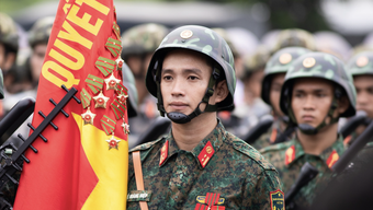
![[Photo] 80th Anniversary of the General Staff of the Vietnam People's Army](https://vphoto.vietnam.vn/thumb/1200x675/vietnam/resource/IMAGE/2025/9/6/49153e2a2ffc43b7b5b5396399b0c471)


![[Photo] Many people directly experience beloved Uncle Ho and the General Secretaries](https://vphoto.vietnam.vn/thumb/1200x675/vietnam/resource/IMAGE/2025/9/6/2f4d9a1c1ef14be3933dbef3cd5403f6)


Comment (0)