

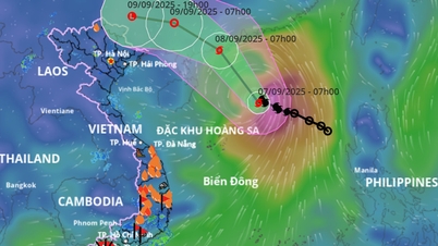
This afternoon (September 6), Mr. Mai Van Khiem, Director of the National Center for Hydro-Meteorological Forecasting, informed about the developments of storm No. 7 that has just formed in the East Sea.
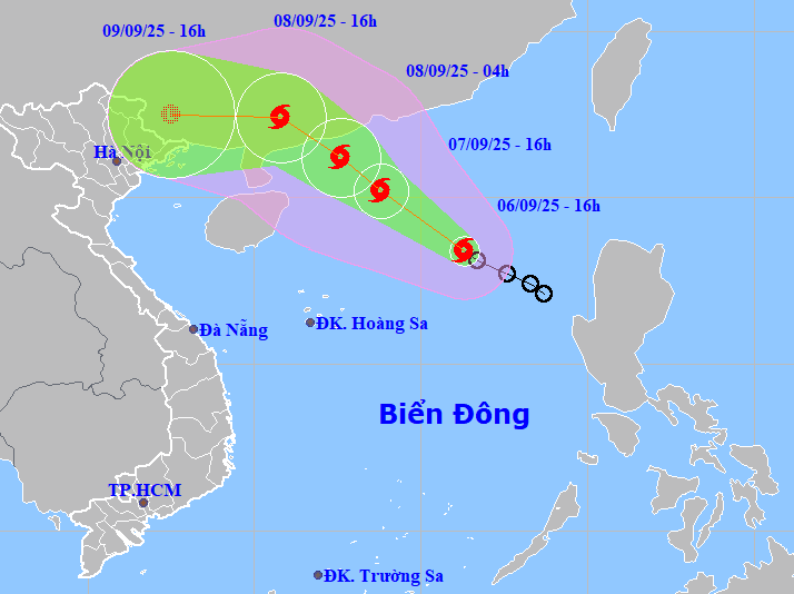
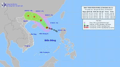
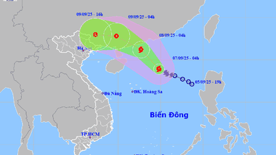
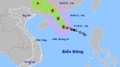
Accordingly, at 4:00 p.m., the center of storm No. 7 (Tapah) was located in the northeastern sea of the East Sea with the strongest wind at level 8 (62-74 km/h), gusting to level 10; moving northwest at a speed of 15 km/h.
Forecast for the next 24 hours, the storm will continue to move northwest at a speed of 10-15km/h and continue to strengthen. By 4pm tomorrow (September 7), the storm center will be about 420km northeast of Hoang Sa archipelago with strong winds of level 9-10, gusting to level 12. Disaster risk level: level 3, northern waters of the East Sea.
In the next 12 hours, the storm maintained its direction, speed of movement and intensified. At 4:00 a.m. on September 8, the center of the storm was about 110 km south-southeast of Hong Kong (China) with strong winds of level 10, gusting to level 13. Disaster risk level: level 3, northwest of the East Sea.
At 4:00 p.m. the same day, the storm continued to move northwest at a speed of about 15 km/h and gradually weakened; located on the mainland of Guangdong province (China); strong winds level 9, gusts level 12. Disaster risk level: level 3, northwest sea area of the East Sea.
In the next 24 hours, the storm will move mainly in a westerly direction, at a speed of about 15km/h, weakening into a tropical depression, then a low pressure area over the mainland of Guangxi province (China); intensity below level 6.
The National Center for Hydro-Meteorological Forecasting said that after making landfall in China, storm No. 7 will quickly weaken into a low pressure area, but then drift westward toward our country.
Therefore, the post-storm circulation No. 7 will cause widespread heavy rain in the North from the afternoon and night of September 9-11, focusing on the midland and mountainous areas of the Northeast.
Due to the storm's influence, the northeastern sea area of the East Sea has strong winds of level 6-7, later increasing to level 7-8; near the storm's center, strong winds of level 9-10, gusting to level 13. Waves are 3-5m high, and the sea is very rough. Ships operating in the danger zone are likely to be affected by storms, whirlwinds, strong winds and large waves.
PVSource: https://baohaiphong.vn/bao-so-7-da-hinh-thanh-tren-bien-dong-kha-nang-tiep-tuc-manh-them-520104.html
![[Photo] Impressive display booths of provinces and cities at the Exhibition 80 years of the Journey of Independence - Freedom - Happiness](https://vphoto.vietnam.vn/thumb/1200x675/vietnam/resource/IMAGE/2025/9/7/cd63e24d8ef7414dbf2194ab1af337ed)

![[Photo] Prime Minister Pham Minh Chinh attends the 80th anniversary of the founding of Voice of Vietnam Radio Station](https://vphoto.vietnam.vn/thumb/1200x675/vietnam/resource/IMAGE/2025/9/7/abdcaa3d5d7f471abbe3ab22e5a35ec9)


![[Photo] General Secretary To Lam attends the 55th anniversary of the first television program broadcast](https://vphoto.vietnam.vn/thumb/1200x675/vietnam/resource/IMAGE/2025/9/7/8b8bd4844b84459db41f6192ceb6dfdd)


![[Highlight] VIMC's mark at the National Achievement Exhibition](https://vphoto.vietnam.vn/thumb/402x226/vietnam/resource/IMAGE/2025/9/7/932133a54d8b4becad48ef4f082f3eea)


![[COMING UP] Workshop: Resolving concerns for Business Households about eliminating lump-sum tax](https://vphoto.vietnam.vn/thumb/402x226/vietnam/resource/IMAGE/2025/9/7/5627bb2d0c3349f2bf26accd8ca6dbc2)


Comment (0)