
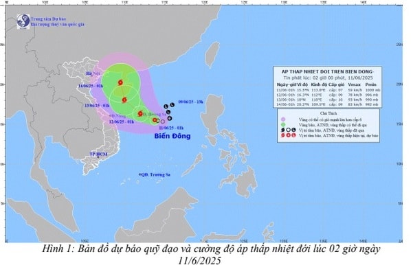
The weather report at nearly 3 a.m. this morning, June 11, from the provincial Hydrometeorological Station, said that at 1 a.m. on June 11, the center of the tropical depression was at about 15.5 degrees north latitude; 113.8 degrees east longitude, about 240 km east southeast of Hoang Sa archipelago. The strongest wind near the center of the tropical depression was level 7 (50-61 km/h), gusting to level 9; moving slowly in a west-northwest direction at a speed of about 5-10 km/h.
Over the next 48 to 72 hours, it will strengthen into a storm and likely change direction, moving northwest at about 10 km/h.
The northern East Sea area (including the waters of the Hoang Sa archipelago), the northern central East Sea area has thunderstorms and strong winds of level 6 - 7, then increasing to level 8 - 9, gusting to level 11, waves 2.5 - 4.5 m high, very rough seas; the southern central East Sea area, the southern East Sea area (including the waters of the Truong Sa archipelago) has strong southwest winds of level 6, sometimes level 7, gusting to level 8 - 9, waves 2.0 - 4.0 m high, rough seas.
From June 12, in the Gulf of Tonkin, there will be thunderstorms and strong winds of level 6, sometimes level 7, gusting to level 8, rough seas, waves 2.0-3.0 m high.
From the night of June 12, the sea areas of Quang Ninh, Hai Phong , Thai Binh, Nam Dinh, Ninh Binh and Thanh Hoa will have thunderstorms and strong winds of level 5, sometimes level 6, gusting to level 7, level 8, rough seas, waves 1.0 - 2.5 m high. All ships and activities in the above sea areas are at high risk of being affected by tornadoes, strong winds and big waves.
Disaster risk level due to strong winds at sea: level 2.
PVSource: https://baohaiduong.vn/ap-thap-nhiet-doi-kha-nang-manh-len-thanh-bao-vung-bien-hai-phong-gio-manh-cap-5-413745.html


Comment (0)