

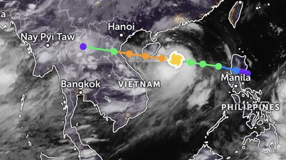
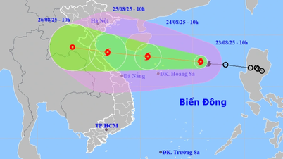
Storm No. 5, internationally named Kajiki, formed from a tropical depression in the eastern sea of the North East Sea on the morning of August 23.

According to the National Center for Hydro-Meteorological Forecasting, at 7:00 a.m. this morning, the storm's center was located at about 17.2 degrees North latitude and 116.6 degrees East longitude, about 480 km East Northeast of Hoang Sa archipelago, the strongest wind near the storm's center reached level 8, gusting to level 10, moving in a West Northwest direction at a speed of about 25 km/hour.
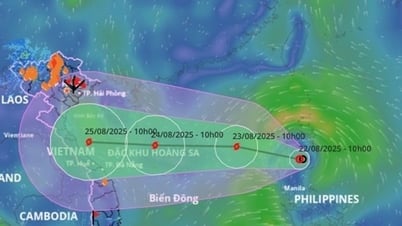
It is forecasted that in the next 24 hours, the storm will continue to move in a West-Northwest direction at a speed of 20-25 km/h and continue to get stronger. By the morning of August 24, the storm center will be near the Hoang Sa archipelago, with winds increasing to level 10-11, gusting to level 14.
On August 25, the storm entered the sea area from Thanh Hoa to Hue with the strongest intensity of level 11-12, gusting to level 15. By August 26, the storm gradually weakened into a tropical depression over the mainland of Central Laos.

The National Center for Hydro-Meteorological Forecasting warns that at sea, the North East Sea area, including Hoang Sa archipelago, there will be strong winds of level 8-9, the area near the storm's eye will reach level 10-11, gusting to level 14, waves 4-6 m high, and rough seas.
From tomorrow afternoon, August 24, the sea area from Thanh Hoa to Hue , including Con Co and Hon Ngu, will have winds gradually increasing to level 6-8, then increasing to level 9-10, near the storm center level 11-12, gusting to level 15, waves 6-8m high.
From the night of August 24, the northern sea area of Bac Bo Gulf, including Bach Long Vi, has strong winds of level 6-7, gusts of level 9, and waves 2-3m high.
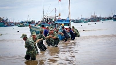
On land, from the night of August 24, the area from Thanh Hoa to Quang Tri will have strong winds of level 7-9, near the storm center level 10-12, gusting to level 14. Widespread heavy rain will occur from the night of August 24 to the end of August 26 with common rainfall of 100-150mm, locally over 250mm; Thanh Hoa to Quang Tri will have rain of 150-300mm, the highest place can exceed 600mm. The risk of extremely heavy rain over 200mm in 3 hours may occur, leading to the risk of flash floods, landslides and inundation.
Storm surges in coastal areas of Thanh Hoa - Quang Tri could be 0.5-1m high, causing water levels in Sam Son, Hon Ngu, Vung Ang and Cua Gianh to exceed 3m.
Director of the National Center for Hydro-Meteorological Forecasting Mai Van Khiem warned that the weather at sea and on coastal land during the storm is extremely dangerous, all means and structures in the dangerous area, from tourist boats, transport ships to aquaculture cages, are unsafe.
Source: https://www.sggp.org.vn/ap-thap-nhiet-doi-da-thanh-con-bao-so-5-post809740.html


![[Photo] General Secretary To Lam attends the 80th Anniversary of the Cultural Sector's Traditional Day](https://vphoto.vietnam.vn/thumb/1200x675/vietnam/resource/IMAGE/2025/8/23/7a88e6b58502490aa153adf8f0eec2b2)
![[Photo] Prime Minister Pham Minh Chinh chairs the meeting of the Government Party Committee Standing Committee](https://vphoto.vietnam.vn/thumb/1200x675/vietnam/resource/IMAGE/2025/8/23/8e94aa3d26424d1ab1528c3e4bbacc45)


Comment (0)