Yesterday, August 3, Hanoi and many provinces and cities in the North were hot and stuffy, with some places experiencing particularly intense heat. In the late afternoon and early evening, people could clearly feel the stuffy weather, even though they were sitting in air-conditioned rooms.
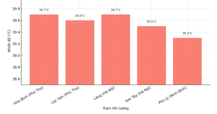
The actual temperature measured during the day in many places reached 40°C such as Hoa Binh station (Phu Tho) 39.7°C; Lac Son station (Phu Tho) 39.6°C; Lang and Son Tay stations (Hanoi) 39.7°C and 39.5°C respectively; Phu Ly station (Ninh Binh) 39.3°C.
The Central region is also scorching hot, with many places recording temperatures from 38 to over 39°C, such as Tuy Hoa station ( Dak Lak ) 39.3°C; Do Luong station (Nghe An) 38.6°C; Hoai Nhon station (Gia Lai) 38.8°C.
The leader of the Hai Phong City Hydrometeorological Station said that at low altitude, the hot low pressure area in the West has developed, combined with the divergence field above, making the weather in the North today hot and humid.
It is forecasted that this weather pattern will last in the North until August 4 with the highest temperature during the day commonly ranging from 36-38°C, with some places experiencing particularly intense heat above 39°C.
From the evening and night of the same day, the North is likely to enter a period of heavy rain and thunderstorms. Rain helps "cool down" but thunderstorms after hot days have a very high risk of thunderstorms accompanied by extreme weather phenomena such as tornadoes, lightning, hail and strong gusts of wind.
According to the forecast of the National Center for Hydro-Meteorological Forecasting, from the evening and night of August 4 to the morning of August 7, the mountainous and midland areas of the North are likely to experience a widespread heavy rain with total rainfall of 50-120 mm, in some places over 250 mm.
Other areas of the North have moderate rain, locally heavy to very heavy rain, total rainfall ranges from 30-80 mm, in some places over 150 mm.
Risk of heavy rain with rainfall of over 100 mm in just 3 hours. Heavy rain in a short period of time, risk of flash floods, landslides in mountainous areas and flooding in urban areas and low-lying areas.
In addition, in the evening and night of August 5, Thanh Hoa and Nghe An may experience scattered showers and thunderstorms, with locally heavy rain.

In August 2025, heat waves will continue to occur in the North, the area from Thanh Hoa to Hue, the South Central Coast, concentrated in the first half of the month, then gradually decrease. In particular, from August 8 to 10, widespread heat waves will recur in the North after days of heavy rain.
In addition to the hot weather, the North and the provinces from Thanh Hoa to Hue are at risk of some widespread heavy rains in August. In the Central Highlands and the South, there will be many days of showers and thunderstorms, mainly in the late afternoon, some days may have moderate to heavy rain.
The East Sea may also experience 1-2 storms or tropical depressions that may affect mainland Vietnam.
Source: https://baohatinh.vn/vi-sao-mien-bac-nang-nong-du-doi-gan-40-do-c-post293055.html





















Comment (0)