
Latest storm news: Currently, a very strong storm, internationally named YINXING, is active in the waters northeast of Luzon Island (Philippines). After passing the northern coast of Luzon Island, the storm is likely to enter the East Sea around November 8.
Latest storm news: Current status of storm YINXING
Currently, a very strong storm, international name YINXING, is active in the sea northeast of Luzon Island (Philippines).
Latest storm news: Update on storm location and direction: How strong is storm Yinxing expected to be when it enters the East Sea?
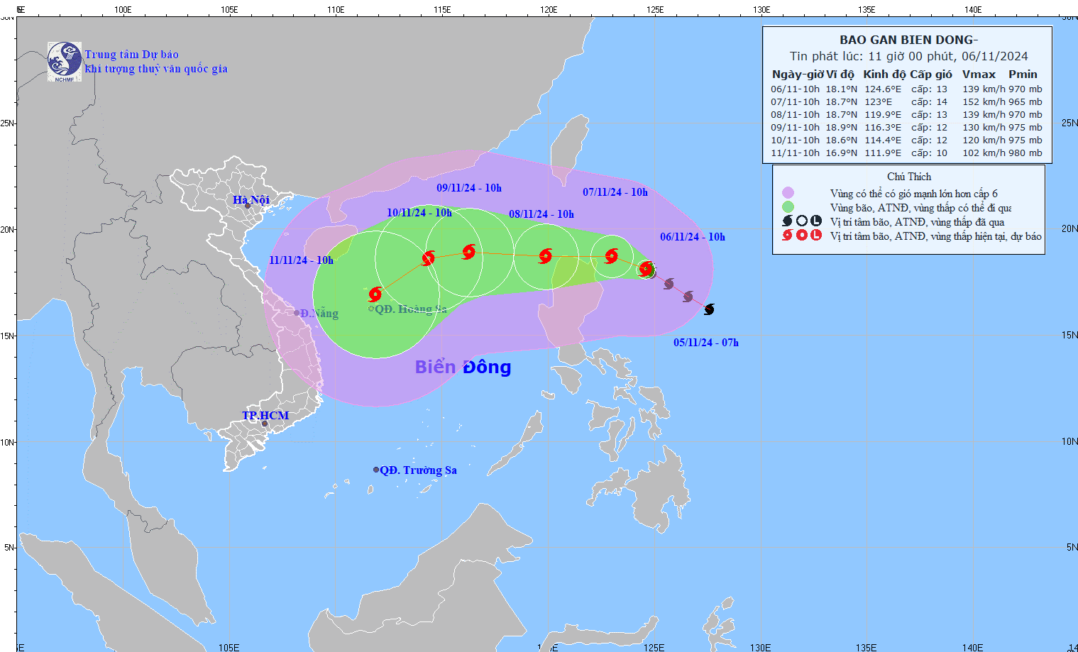
At 10:00 a.m. on November 6, the center of the storm was located at approximately 18.1 degrees North latitude; 124.6 degrees East longitude, in the sea northeast of Lu Dong island. The strongest wind near the center of the storm was level 13 (134-149 km/h), gusting to level 16. Moving northwest at a speed of approximately 15 km/h.
Forecast of storm YINXING in the next 24 to 72 hours:
Forecast time | Direction, speed | Location | Intensity | Danger zone | Disaster Risk Level (Affected Area) |
10h/07/11 | West Northwest, 5-10km/h | 18.7N-123.0E; on the sea to the south Northeast of Luzon Island (Philippines) | Level 14, jerk level 17 | Latitude 17.0N-21.0N; East of longitude 121.0E | |
10h/08/11 | West, 10-15km/h, go into the East Sea | 18.7N-119.9E; East of the North East Sea area | Level 13, jerk level 16 | Latitude 17.0N-21.0N; East of longitude 118.0E | Level 3: East of the North East Sea area |
10:00/09/11 | West, about 15km/h , | 18.9N-116.3E; in the North East Sea area, 510km northeast of Hoang Sa archipelago | Level 12, jerk level 14 | Latitude 17.0N-21.0N; East of longitude 114.5E | Level 3: East of the North East Sea area |
From the next 72 to 120 hours, the storm is likely to change direction to move West Southwest, traveling about 15km per hour, and continue to weaken.
Sharing with Dan Viet a few minutes ago, Mr. Vu Anh Tuan - Deputy Head of Weather Forecast Department, National Center for Hydro-Meteorological Forecasting, gave updates on storm Yinxing (at 11:00 a.m. on November 6, 2024).
Mr. Vu Anh Tuan - Deputy Head of Weather Forecast Department, National Center for Hydro-Meteorological Forecasting has updated on storm Yinxing (at 11:00 a.m. on November 6, 2024). Source: NCHMF
Specifically, expert Vu Anh Tuan shared: "As of this morning, the Center for Hydro-Meteorological Forecasting has released the first information about this storm YINXING. As of 10:00 a.m. this morning, the storm is still in the northeastern sea area of the Philippines. And is currently moving in a West-Northwest direction towards the North of Luzon Island."
According to the Deputy Head of the Weather Forecast Department, the latest update is that around November 8-11, storm YINXING is likely to enter the eastern part of the East Sea and become the 7th storm active in the East Sea in 2024.
When entering the eastern sea area of the North East Sea, the storm has an intensity of about level 12-13. When entering the East Sea, under the influence of cold air, the sea surface temperature decreases and the impact of the environment changes, so the intensity of the storm also changes, especially when entering the northeastern sea area of the Hoang Sa sea area.
"The latest assessment of the National Center for Hydro-Meteorological Forecasting is that on November 8-9-10, the storm will likely move north of the Northeast to the North of the Hoang Sa sea area, then gradually shift to the West Southwest and head towards the Hoang Sa archipelago area.
Regarding the trajectory of storm No. 7, if it is likely to move over the East Sea, it will be concentrated. However, the intensity of storm No. 7 among forecasting centers in the region is changing, so it is necessary to closely monitor this storm," Mr. Vu Tuan Anh emphasized.
On the impact of typhoon YINXING
The eastern sea area of the North East Sea has strong winds of level 6-7. From the evening and night of November 7, it will increase to level 8-10, near the storm center it will be level 11-13, gusting to level 16, waves 4.0-6.0m high, near the center 6.0-8.0m; rough seas.
Ships operating in the above mentioned dangerous areas are likely to be affected by storms, whirlwinds, strong winds and large waves.
Source: https://danviet.vn/nong-tin-bao-moi-nhat-bao-yinxing-sap-vao-bien-dong-duoc-du-bao-manh-co-nao-2024110611485038.htm


![[Photo] Discover the "wonder" under the sea of Gia Lai](https://vphoto.vietnam.vn/thumb/1200x675/vietnam/resource/IMAGE/2025/8/6/befd4a58bb1245419e86ebe353525f97)
![[Photo] Nghe An: Provincial Road 543D seriously eroded due to floods](https://vphoto.vietnam.vn/thumb/1200x675/vietnam/resource/IMAGE/2025/8/5/5759d3837c26428799f6d929fa274493)


Comment (0)