
According to the National Center for Hydro-Meteorological Forecasting, from 11:40 a.m. to 4:40 p.m. on June 8, the mountainous provinces of the North will continue to have rain with accumulated rainfall ranging from 20-50mm, with some places over 80mm.
Risk of flash floods on small rivers and streams, landslides on steep slopes in the following localities: Nam Nhun, Phong Tho, Sin Ho, Tam Duong, Tan Uyen, Than Uyen, Lai Chau city (Lai Chau province); Muong Cha, Tua Chua, Tuan Giao, Muong Lay town (Dien Bien province); Bac Yen, Mai Son, Muong La, Song Ma, Sop Cop, Thuan Chau (Son La province); Bac Ha, Bao Thang, Bao Yen, Bat Xat, Muong Khuong, Simacai, Sa Pa town, Van Ban (Lao Cai province); Mu Cang Chai (Yen Bai province); Bac Me, Bac Quang, Hoang Su Phi, Quan Ba, Vi Xuyen, Xin Man, Yen Minh (Ha Giang province); Pac Nam ( Bac Kan province); Bao Lac, Bao Lam (Cao Bang province).
Warning level of natural disaster risk due to flash floods, landslides, land subsidence due to heavy rain or water flow level 1; Tam Duong district, Lai Chau province level 2.
Heavy rains are likely to cause flooding in low-lying areas, urban and industrial areas; flash floods on small rivers and streams, landslides on steep slopes (real-time warning information on areas at risk of flash floods and landslides is provided online on the website of the Department of Hydrometeorology at: https://luquetsatlo.nchmf.gov.vn and in separate bulletins warning of flash floods and landslides).
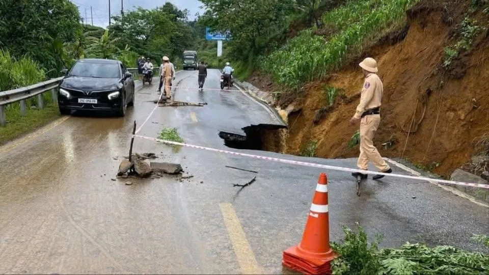
Flash floods and landslides can have very negative impacts on the environment, threaten people's lives; cause local traffic congestion, affect the movement of vehicles; destroy civil and economic works, causing damage to production and socio-economic activities.

The hydrometeorological agency noted that people need to regularly monitor forecast and warning information on the website of the National Center for Hydro-Meteorological Forecasting at nchmf.gov.vn , and provincial, municipal and regional hydrometeorological stations.
At the same time, regularly update the latest hydrometeorological forecast information on the official mass media of the Central and local levels, to proactively respond, recommend that the authorities in the affected localities pay attention to reviewing the flow bottlenecks and key locations in the area to take preventive measures.
According to the guidance of the Department of Dyke Management and Natural Disaster Prevention and Control (Ministry of Agriculture and Environment), in the face of the above situation, affected areas should closely monitor developments of heavy rain, flooding, flash floods, landslides, and promptly and fully inform authorities at all levels and people to proactively prevent, respond, and minimize damage.
Localities deploy shock forces to inspect and review residential areas along rivers, streams, and low-lying areas to proactively organize the relocation and evacuation of people in areas at high risk of deep flooding, flash floods, and landslides; organize forces ready to control and direct traffic, and place warning signs, especially through culverts, spillways, and areas with deep flooding and fast-flowing water; proactively arrange forces, materials, and means to overcome incidents, ensuring smooth traffic on main traffic routes when heavy rain occurs.
From 4am to 10am on June 8, the provinces in the Northern mountainous region had moderate to heavy rain, and some places had very heavy rain such as Muong Khoa (Lai Chau) 252.8mm, Muong Leo (Lai Chau) 90mm, Hang Chu (Son La) 84.4mm; Seo Chong Ho Hydropower Plant (Lao Cai) 125mm, Ta Van (Lao Cai) 113.6mm; Tram Tau (Yen Bai) 64.4mm; Ngam La (Ha Giang) 106mm...
Soil moisture models show that some areas in the above provinces are close to saturation (over 85%) or have reached saturation.
Source: https://www.sggp.org.vn/canh-bao-lu-quet-sat-lo-dat-o-8-tinh-vung-nui-bac-bo-post798650.html


![[OCOP REVIEW] Tu Duyen Syrup - The essence of herbs from the mountains and forests of Nhu Thanh](https://vphoto.vietnam.vn/thumb/402x226/vietnam/resource/IMAGE/2025/6/5/58ca32fce4ec44039e444fbfae7e75ec)


Comment (0)