

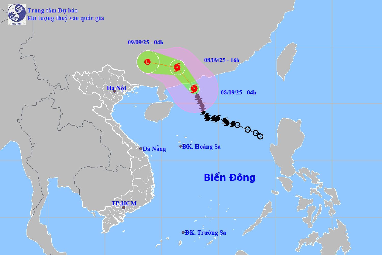
According to the National Center for Hydro-Meteorological Forecasting, at 4:00 a.m. on September 8, the center of storm No. 7 was located at about 21.3 degrees north latitude, 112.9 degrees east longitude, in the northwest sea area of the northern East Sea. The strongest wind near the center of the storm is level 10 - 11 (89 - 117 km/h), gusting to level 13. Moving in a north-northwest direction, at a speed of about 20 - 25 km/h.
It is forecasted that in the next 12 hours, storm No. 7 will move northwest, at a speed of about 20 - 25 km/hour. At 4:00 p.m. on September 8, the center of storm No. 7 will be on the mainland of Guangdong province (China), with a strength of level 8, gusting to level 10.
At 4:00 a.m. on September 9, storm No. 7 weakened and gradually dissipated on land in Guangxi province (China).
Due to the impact of storm No. 7, the northwest sea area of the northern East Sea has strong winds of level 7-8, near the center of the storm are strong winds of level 9-11, gusts of level 13; waves are 4-6 m high, and the sea is very rough. Ships operating in the above-mentioned dangerous areas are likely to be affected by storms, whirlwinds, strong winds, and large waves.
Although not directly affected, areas on the far edge of the storm's circulation such as the Gulf of Tonkin and the eastern coastal areas of the North may experience thunderstorms, tornadoes and strong gusts of wind.
PVSource: https://baohaiphong.vn/bao-so-7-giat-cap-13-tren-khu-vuc-bac-bien-dong-520220.html


![[Photo] General Secretary To Lam chaired the Politburo's working session with the Standing Committees of Party Committees of Central Party agencies.](https://vphoto.vietnam.vn/thumb/1200x675/vietnam/resource/IMAGE/2025/9/9/8343386e1e8f43c6a3c0543da7744901)


![[Photo] Cambodia's Techo International Airport Officially Opens](https://vphoto.vietnam.vn/thumb/1200x675/vietnam/resource/IMAGE/2025/9/9/330836bb28ad4ee4bdd512cc1a2d0849)


![[Photo] Politburo works with the Standing Committees of Vinh Long and Thai Nguyen Provincial Party Committees](https://vphoto.vietnam.vn/thumb/1200x675/vietnam/resource/IMAGE/2025/9/8/4f046c454726499e830b662497ea1893)


Comment (0)