

.gif)
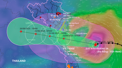
According to the Hai Phong City Hydrometeorological Station, at 4:00 a.m. on August 24, the center of storm No. 5 was at about 17.6 degrees north latitude; 111.7 degrees east longitude, in the sea north of Hoang Sa special zone, about 660km east-southeast of Nghe An, about 640km east of Ha Tinh . The strongest wind near the center of the storm was level 12 (118-133km/h), gusting to level 15; moving west at a speed of about 20km/h.
It is forecasted that in the next 24 - 60 hours, storm No. 5 will move in a west-northwest direction. At 4:00 a.m. on August 25, the center of the storm will be at 18.3 degrees north latitude, 107.8 degrees east longitude; in the southern part of the Gulf of Tonkin; about 230km from Nghe An , about 210km east of Ha Tinh; wind gusts at level 12 - 13, gusts at level 15 and may become stronger.
Dangerous area at latitude 16 - 20 degrees north; from 106.5 - 114.5 degrees east. The sea area west of the northern East Sea (including Hoang Sa special zone), Bac Bo Gulf, the southern sea; Quang Tri - Hue city (including Hon Ngu island, Con Co special zone) has strong gusts of wind and heavy rain.
Due to the impact of the storm, the sea area west of the northern East Sea (including Hoang Sa special zone) has strong winds of level 8 - 10, the area near the storm's eye has winds of level 11 - 13, gusts of level 15, waves 5 - 7m high, the area near the storm's eye has waves of 7 - 9m, and the sea is very rough.
From noon and afternoon of August 24, the sea area from Thanh Hoa to Hue city (including Hon Ngu island, Con Co special zone) will have winds gradually increasing to level 6 - 8, then increasing to level 9 - 10, near the storm center level 11 - 13, gusting to level 15; waves 4 - 6m high, near the center 7 - 9m; rough seas.
From the afternoon of August 24, the North of Bac Bo Gulf (including the special zones: Cat Hai, Co To, Van Don) has winds gradually increasing to level 6 - 7, gusting to level 9; the South of the North of Bac Bo Gulf (including the special zone Bach Long Vi) has strong winds of level 8, gusting to level 10; waves 2 - 4m high; rough seas.
Coastal areas from Ninh Binh to Northern Quang Tri have storm surges of 0.5 - 1.5 m. Water levels at Sam Son (Thanh Hoa) are 3.3 - 3.8 m high, at Hon Ngu (Nghe An) are 3.5 - 4 m high, at Vung Ang (Ha Tinh) are 2.5 - 3 m high and at Cua Gianh (Quang Tri) are 1.5 - 2 m high. There is a high risk of flooding in low-lying coastal areas, river mouths, and islands from Thanh Hoa to Northern Quang Tri.
Weather warning at sea, coastal mainland during storm is extremely dangerous, unsafe for any vehicle, construction operating in dangerous areas such as: Cruise ships, passenger ships, transport ships, cages, rafts, aquaculture areas, dykes, embankments, coastal routes. Vehicles are highly likely to capsize, be destroyed; flooded due to strong winds, big waves and rising sea levels.
From the night of August 24, on land from Thanh Hoa to Quang Tri, winds will gradually increase to level 7 - 9, near the storm center, level 10 - 12, gusting to level 14 - 15; coastal areas from Quang Ninh to Ninh Binh, winds will gradually increase to level 6 - 7, gusting to level 8.
From the night of August 24 to the end of August 26, in the Northern Delta, South Phu Tho and from Thanh Hoa to Hue city, there is a possibility of widespread heavy rain with common rainfall of 100 - 150mm, locally over 250mm; in particular, the area from Thanh Hoa to North Quang Tri will have heavy to very heavy rain with common rainfall of 200 - 400mm, locally over 700mm. Warning of the risk of heavy rain (>200mm/3 hours).
Impact of storms on Hai Phong city
From the afternoon of August 24, the northern sea area of Bac Bo Gulf (including Bach Long Vi special zone) has strong winds of level 8, gusts of level 10, waves 2.0-4.0m high; rough seas.
From the night of August 24, the sea area of Cat Hai special economic zone has strong winds of level 6-7, gusts of level 8-9, waves 1.0-2.0m high, rough seas.
From the night of August 24, coastal waters of the wards of Hai An, Dong Hai, Nam Trieu, Do Son, Nam Do Son, Duong Kinh; communes of Chan Hung, Hung Thang, Kien Hai will have winds gradually increasing to level 4 - 5, gusting to level 6 - 7, waves 0.5 - 1m high.
From the morning of August 25, Thuy Nguyen, Thien Huong, Hoa Binh, Bach Dang, Luu Kiem, Le Ich Moc wards, Viet Khe commune, Hong Bang ward, Hong An ward, Ngo Quyen ward, Gia Vien ward, Le Chan ward, An Bien ward, An Duong ward, An Hai ward, An Phong ward, An Truong commune, Kien An ward, Phu Lien ward, Hung Dao ward, An Hung commune, An Khanh commune, An Quang commune, An Lao commune, Kien Thuy commune, Kien Minh commune, Kien Hung commune, Nghi Duong commune, Quyet Thang commune, Tien Lang commune, Tan Minh commune, Tien Minh commune, Vinh Bao commune, Nguyen Binh Khiem commune, Vinh Am commune, Vinh Hai commune, Vinh Hoa commune, Vinh Thinh commune, Vinh Thuan commune have winds of level 3 - 4, sometimes level 5, gusting to level 6, affected by strong winds.
Warning: Coastal mainland areas during storms are extremely dangerous and unsafe for any vehicles or structures operating in the danger zone such as: cruise ships, passenger ships, transport ships, cages, rafts, aquaculture areas, dykes, embankments, coastal routes. Vehicles are at high risk of capsizing, destruction; flooding due to strong winds, big waves and rising sea levels. All boats, anchorages, aquaculture areas, sea dykes and other activities in the above sea areas are at very high risk of being affected by storms, whirlwinds, strong winds and big waves. Strong winds and strong gusts can break trees, damage houses, traffic works and infrastructure, endangering human lives. Natural disaster risk level due to storms is level 3.
From the night of August 24 to the end of August 26, the entire city of Hai Phong will have moderate to heavy rain, some places will have very heavy rain and thunderstorms.
In the Gulf of Tonkin (including Bach Long Vi special zone), there will be heavy to very heavy rain and thunderstorms, with common rainfall from 100-150mm.
In the Hai Phong sea area (including Cat Hai special zone, Do Son ward), there is moderate to heavy rain, some places have very heavy rain with common rainfall from 80-120mm, locally over 120mm.
Inland areas (including all remaining communes/wards) have moderate to heavy rain, some places have very heavy rain with common rainfall of 50-100mm, some places have over 100mm. During thunderstorms, there is a possibility of tornadoes, lightning and strong gusts of wind.
Source: https://baohaiphong.vn/bao-so-5-giat-cap-15-huong-vao-bac-trung-bo-hai-phong-canh-bao-mua-lon-va-gio-manh-518946.html

![[Photo] The ceremonial artillery is ready to "fire" for the second parade rehearsal at My Dinh National Stadium.](https://vphoto.vietnam.vn/thumb/1200x675/vietnam/resource/IMAGE/2025/8/24/883ec3bbdf6d4fba83aee5c950955c7c)


![[Photo] Impressive image of 31 planes taking flight in the sky of Hanoi during their first joint training](https://vphoto.vietnam.vn/thumb/1200x675/vietnam/resource/IMAGE/2025/8/24/2f52b7105aa4469e9bdad9c60008c2a0)


Comment (0)