
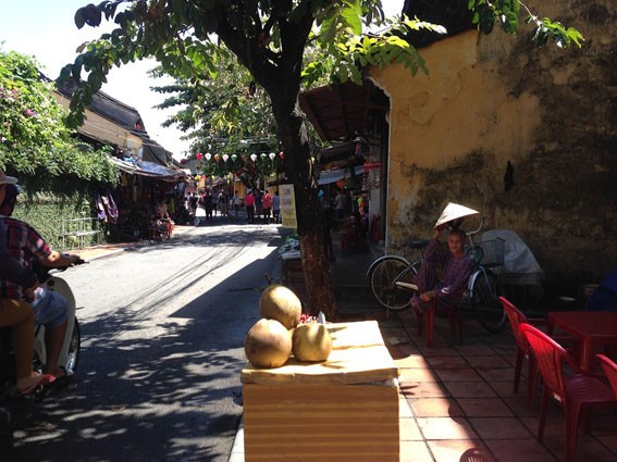
A big brand for business people to "take refuge"
PSG.TS Do Bang from the Thua Thien Hue Historical Association said that when Lord Nguyen Hoang and the governor of Quang Nam citadel, Nguyen Phuc Nguyen, wrote many letters calling for foreign merchants to come and trade. Meanwhile, the West turned to the East, Japanese and Chinese merchants came to Hoi An and stayed here to build streets, creating a very unique urban area, a blend of many cultures.
Lord Nguyen allowed Japanese and Chinese merchants to choose a place near the Hoi An port to establish a trading town and settle permanently. From then on, two autonomous neighborhoods of the Japanese and Chinese were formed in Hoi An. They lived separately, appointed their own rulers, and followed the customs and practices of each country.
At the above mentioned time in Quang Nam land, Lord Nguyen also received many Portuguese and Dutch merchant ships to trade and planned to grant the Portuguese in the area near Da Nang port 3 - 4 miles of land to establish a town with the same amenities and incentives as Lord Nguyen had given to the Japanese and Chinese.
Information from an international conference on Hoi An in 1990 showed that in the 17th century, the urban appearance of Hoi An was determined as follows: To the east was the Japanese town, located downstream of the river; To the west was the Nhan Pho (Chinese town), located upstream of the river; To the south was the big river (Thu Bon river at that time); To the north was the An Nam town (ie Vietnamese town).
 |
The Japanese Quarter is located in Hoai Pho village, an ancient village, so the Thu Bon River section flowing through Hoi An town is also called Hoai River. The place name Faifo (the French name for Hoi An) also originates from the name of the village and the river. Hoai Pho village was recorded in the book O Chau Can Luc (1555). In the 18th century, the village changed its name to Hoa Pho; later it was changed to Son Pho village. Son Pho is currently in Cam Chau commune, Hoi An city.
According to Dr. Do Bang, the Japanese came to buy 20 hectares of land in Hoai Pho and An My villages to build streets and live; and established a pagoda named Tung Bon. “In the Pho Da Son Linh Trung Phat stele in Ngu Hanh Son (Da Nang) engraved in 1640, which we surveyed and published in 1985, there were 9 mentions of the place name Dinh Nhat Bon and one mention of the address Dinh Tung Bon, where the Japanese lived in Hoi An and donated a lot of money to this pagoda. This was the heyday of the Japanese town in Hoi An, so Westerners called Hoi An a Japanese city. The first mayor recognized in 1618 was Furamoto Yashiro; there were many mayors with great power in Dang Trong such as Simonosera. There was a mayor who intervened with Lord Nguyen to grant special favors to Alexandre de Rhodes during the period when Christianity was banned,” Associate Professor Dr. Do Bang shared.
Many relics show that the Japanese people's activities and lifestyle in Hoi An were very prosperous, from markets, ports, ships passing by to Japanese burials here: "In 1981, we also found 4 ancient tombs of Japanese people in Hoi An, also recording the year of death in the last decade of the 17th century." (According to "The City of Dang Trong under the Nguyen Lords", Dr. Do Bang)
The Japanese Quarter in Hoi An was born and flourished in the first half of the 17th century and lasted until the end of that century. Due to many embargo policies, the Japanese had to return home, the remaining ones married Chinese and Vietnamese people and gradually faded away.
 |
In 1618, Chinese merchants began to gather in Hoi An. In addition to the horizontal plaque with the year Thien Khai - Tan Dau year (1621) still kept by a Chinese family on Tran Phu street, it is considered the oldest relic of the Khach town.
Documents also show that during the prosperous time of the Khach town, the Chinese built a temple named Cam Ha palace in 1626, on the border of Cam Pho and Thanh Ha villages, located to the west of the present-day Hoi An city. Many documents prove that the Chinese came to Hoi An to buy land to build the town through real estate purchase and sale contracts on Tran Phu street today.
Tran Phu Street at that time became a crowded Chinese neighborhood with two rows of streets appearing as described by Bowyear (1695): "This port has only one large street on the riverbank, on both sides there are two rows of 100-roofed houses, all inhabited by Chinese people".
Also in 1695, Thich Dai San came to Hoi An and recorded in the Overseas Chronicle (translated by Hue University, 1963): “A 3-4 mile long street along the river bank is called Dai Duong Nhai. The streets on both sides are closely connected. The owners of the streets are all Fujian people who still dress in the style of the ancient dynasty.”
Researcher Chau Phi Co in the article “Hoi An 400 years of history” said: “The Japanese built the street at the beginning of the sunrise side of the city, while the Chinese built the street at the end of the sunset side”. After the connection between the Japanese and the Chinese, the heritage of Hoi An became more vivid. The Japanese built a bridge called the Japanese Bridge (Lai Vien Kieu), the Chinese built a pagoda on it to worship the Northern Emperor, so it was called Cau Pagoda. This is a place that everyone who comes to Hoi An visits.
The map Thien Nam tu chi lo do thu drawn by Do Ba (1630 - 1655) showed the names Hoi An street, Hoi An style... which helped us confirm that Hoi An street and Hoi An bridge (Japanese bridge) were born in the first half of the 17th century.
 |
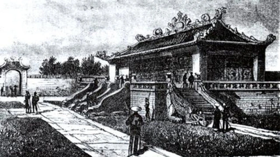
Heritages such as Hoi An communal house and Ong Voi temple on Le Loi street are now considered by historians to be in addition to the Chinese and Japanese quarters, there was also a Vietnamese urban area established in the first half of the 17th century. Thus, in the heart of Hoi An, there are Japanese, Chinese and Vietnamese people living, creating a diverse and connected urban area, although the customs of the community still follow their own way.
Decline due to time and geography
After a period of prosperity, Hoi An could no longer maintain its position as a leading commercial port in Vietnam. Partly due to geographical changes, partly due to the Nguyen Dynasty's policy of valuing Da Nang port more.
In the 19th century, many lagoons and lakes were deformed. The silting up of Cua Dai was one of the factors leading to the decline of Hoi An commercial port. The Thu Bon and Cho Cui rivers changed their course, and some sections that were previously deep creeks were silted up and dried up, forming new areas of land. When Hoi An no longer had lagoons deep and wide enough to anchor ships, the economic significance of this land gradually diminished.
This was also the period when the Nguyen Dynasty implemented the policy of "closed-door policy". "The more important the position of Da Nang became, the more obscure the position of Hoi An became. Da Nang became an ideal trading port in the Central region - the target of Western imperialist countries, a strategic gateway to penetrate and conquer Vietnam", Dr. Ta Hoang Van commented in the article "Urban planning and architecture of Hoi An under the Nguyen Lords".
An English merchant named Chapman came to Hoi An and saw the desolation of the town after the Tay Son period. He wrote: “When I came to Hoi An, this big city had very little left of the well-planned streets of brick houses and stone-paved streets. I only saw a desolate scene that made me feel sad. Oh my God, those structures now only remain in my memory.” (According to “Hoi An Ancient Town Architecture” - Vietnam, The Gioi Publishing House 2003).
 |
According to Dr. Ta Hoang Van, there were many factors that led to the decline of Hoi An, “After the Tay Son period, Hoi An could not recover. At the end of the 18th century, neither Dang Trong nor Dang Ngoai had any European trading posts left, and their trade in Hoi An gradually declined. In the years 1792 - 1793, Hoi An was only a stopover for unsold shipments. Losing its role as a commercial hub, Hoi An played the role of “a pioneer port for Da Nang”.
By the 20th century, when the North-South railway from Quy Nhon to Da Nang appeared, the national highway was paved, "Hoi An was like a forgotten bag of goods, mansions, streets, and ports were also built along that road in Da Nang" (according to "Vietnam's commercial economy under the Nguyen Dynasty" - Do Bang, Thuan Hoa Publishing House 1977).
Dr. Ta Hoang Van said that, in addition to the changing political policies towards foreign traders, the phenomenon of changing rivers was also seen in other cities. Therefore, all sources of goods flowed to the Da Nang hub. “By 1847, only the Da Nang seaport had many ships passing by. The more Da Nang grew, the more lonely Hoi An became, lying quietly by the shallow river,” Mr. Van expressed.
On October 9, 1888, King Thanh Thai issued an edict establishing Faifo town (Hoi An) as the provincial capital of Quang Nam. On October 9, 1905, the railway line was opened. Da Nang became the most dominant seaport city in the Central region at that time.
In the late 19th century, Da Nang was considered an important strategic location by the Nguyen Dynasty. To strengthen the defense of the country, the Nguyen Dynasty established a mountain fortress in Quang Nam. The political, economic and social center of Quang Nam was still the provincial capital of La Qua (Dien Ban) and Hoi An, where the French Embassy was located. In his memoir “Journey to the South”, Captain John White described “Hoi An was falling into poverty and decline, with no visitors, except for the local fleet and a small ship from the North…” ( Xua va Nay Magazine, 1998).
Source: https://baophapluat.vn/nho-ve-thuong-cang-hoi-an-post551040.html


![[OCOP REVIEW] Tu Duyen Syrup - The essence of herbs from the mountains and forests of Nhu Thanh](https://vphoto.vietnam.vn/thumb/402x226/vietnam/resource/IMAGE/2025/6/5/58ca32fce4ec44039e444fbfae7e75ec)


Comment (0)