Although not the strongest storm ever to hit northern Vietnam, Typhoon Wipha has attracted the attention of experts due to its unusual structure, ability to cause prolonged rain, and distribution of strong winds in areas far from the storm's center.
This is considered one of the clear signs that Vietnam is entering a series of extreme weather, stemming from the ENSO climate phase transition phenomenon.
According to Dr. Nguyen Ngoc Huy, an expert with 20 years of research on natural disaster risk reduction, storm Wipha is accompanied by local strong winds that can occur in a narrow band hundreds of kilometers away from the storm's center.
"Although local strong winds only occur for a short period of about 10 to 15 minutes, high winds can rip off corrugated iron roofs and knock down trees," Dr. Huy emphasized.
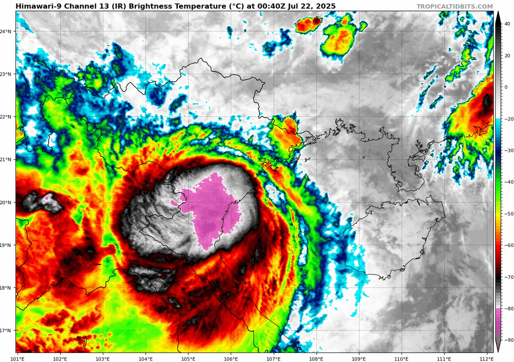
Satellite images show storm Wipha making landfall in northern Vietnam on the morning of July 22 (Photo: Tropicaltidbits).
ENSO: The factor shaping unusual storms
The recent storm surge is not an isolated issue but a manifestation of a shifting climate, particularly the El Niño Southern Oscillation (ENSO) sequence.
ENSO is a natural oscillation of sea surface temperatures and atmospheric conditions in the equatorial Pacific Ocean, creating three climate states: El Niño (warm phase), La Niña (cold phase) and neutral.
From late 2023 to mid-2025, the world witnessed a series of rapid ENSO phase transitions, from El Niño to neutral, then tilted slightly toward La Niña, and is currently in a negative neutral state (closer to La Niña).
These shifts have profound impacts on regional weather, especially in Southeast Asia, where Vietnam is directly affected.
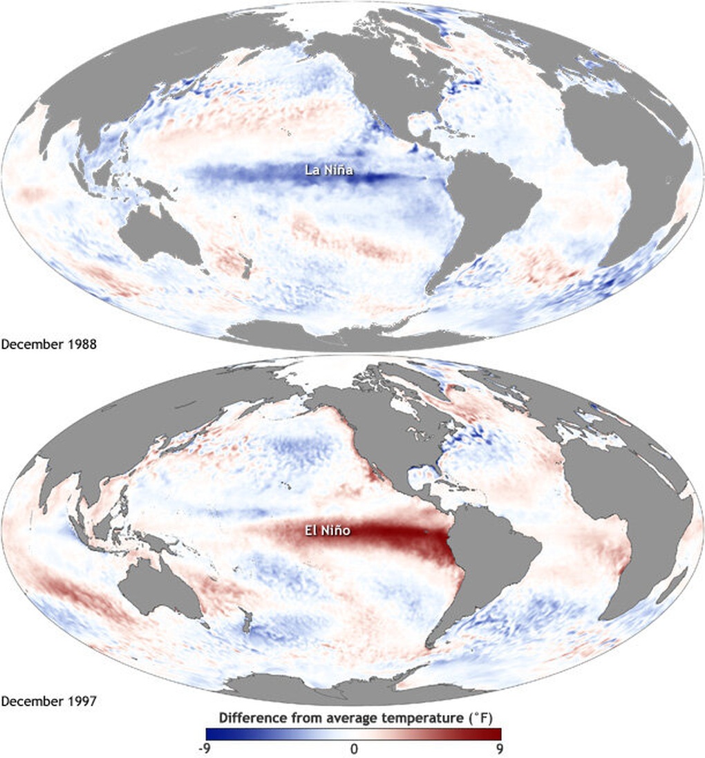
Map showing anomalies of sea surface temperatures in the Pacific Ocean during La Niña and El Niño transitions (Photo: NOAA).
Many climate studies in the Northwest Pacific have shown that ENSO phase shifts have a strong influence on the frequency, location, and intensity of tropical cyclones.
During the El Niño phase, storms tend to form further east, with little direct impact on Vietnam. In contrast, during the La Niña or negative neutral phase, storms tend to form closer to shore, directly hitting the mainland with a higher frequency than the multi-year average.
Typhoon Wipha is a typical example. Although not a super typhoon, its asymmetrical structure, strong moisture absorption in the Southeast compared to the Northwest, combined with the phenomenon of energy enhancement when moving slowly over the Gulf of Tonkin, made it a dangerous storm.
In particular, Wipha caused prolonged rain after the storm, a scenario commonly seen during La Niña or negative neutral phases, when the atmosphere retains a lot of moisture and forms "atmospheric rivers" that carry huge amounts of water vapor from the sea to the land.
As a result, the rains after the storm became the main cause of landslides and flash floods, especially in the northern mountainous provinces and coastal areas.
Long-term response: Urgent problem
From the experience of Typhoon Wipha and climate transitions, the clearest lesson is that no storm should be taken lightly.
The impact of a storm comes not only from the wind force when it makes landfall, but also from the rainfall that lasts for many days after the storm, the areas affected hundreds of kilometers away from the storm center, or the local strong wind phenomena that only last for a few minutes but have great destructive power. These are very typical manifestations during the ENSO instability period.

The impact of a storm comes not only from the wind when it makes landfall, but also from the rainfall that lasts for days afterward (Photo: Getty).
Reinforcing houses, pruning trees, and evacuating from dangerous areas are no longer temporary solutions when storms approach, but must become part of a long-term adaptation strategy to extreme climate.
Especially in Vietnam, where the terrain is steep, the population is widely distributed and infrastructure is uneven, an average storm can cause serious consequences if combined with prolonged periods of extreme rain.
Not only authorities, but also each community and each household, need to be equipped with knowledge about storms and climate change to proactively respond.
Source: https://dantri.com.vn/khoa-hoc/giai-ma-chuyen-pha-khi-hau-vi-sao-cac-con-bao-ngay-cang-bat-on-20250722083736920.htm








































Comment (0)