

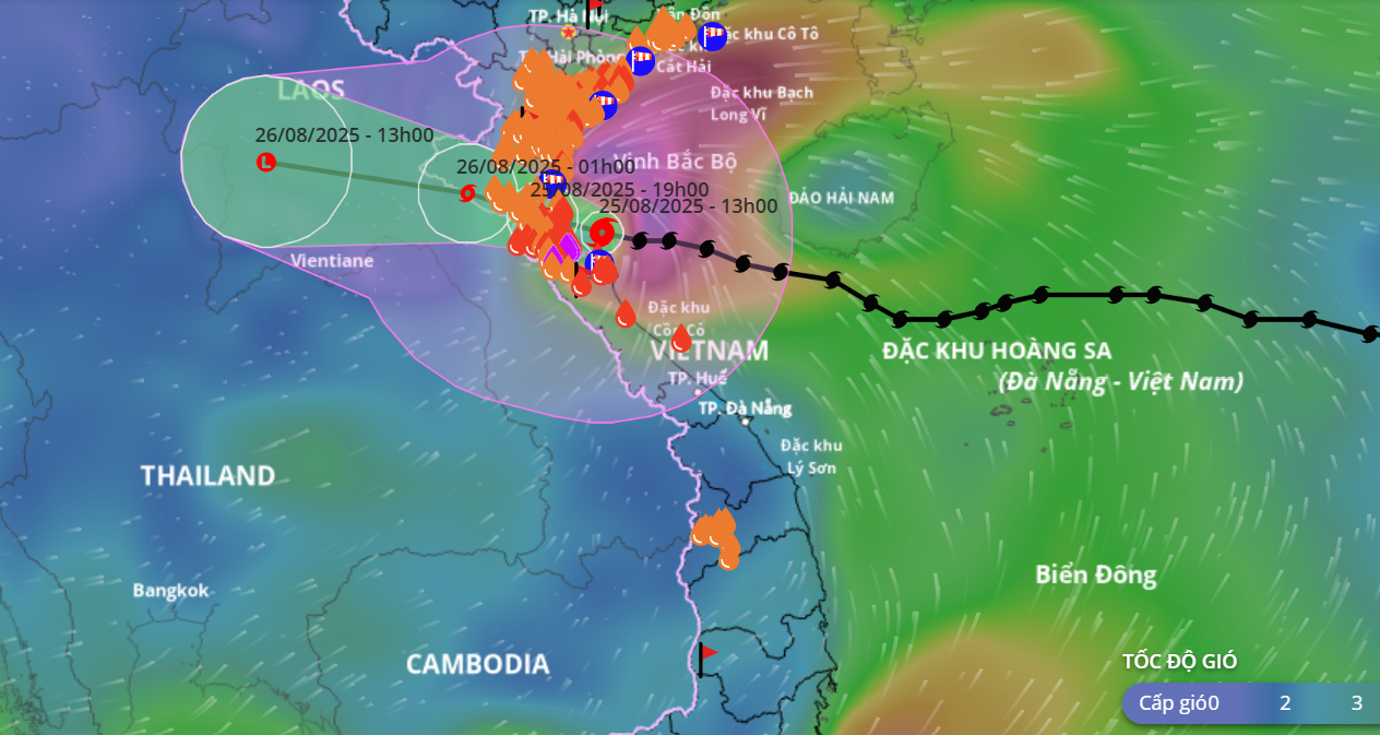
The path of storm No. 5 recorded at 2:00 p.m. on August 25. Photo: vndms
Forecast until 7pm tonight (August 25), the eye of the storm is located on the mainland from Thanh Hoa to Ha Tinh provinces. The strongest wind near the eye of the storm is level 10-11, gusting to level 13; moving in the West Northwest direction at a speed of 15-20km/hour.
At 1:00 a.m. on August 26, the storm moved in a West-Northwest direction at a speed of 15-20 km/h on the Vietnam-Laos border, with strong winds of level 8, gusting to level 10.
By 1:00 p.m. on August 26, it gradually weakened into a low pressure area.
In the next 06 to 24 hours:
The sea area from Thanh Hoa to Quang Tri (including Hon Ngu island, Con Co special zone) has strong winds of level 8-11, near the storm's eye level 12-13, gusting to level 16; waves 5-7m high, near the storm's eye 8-10m; rough seas.
On land, in the North Thanh Hoa area, there will be strong winds of level 8-9, gusting to level 10-11; in the South Thanh Hoa-North Ha Tinh area, there will be strong winds of level 10-11, near the storm center, there will be level 12-13, gusting to level 14-15; in the South Ha Tinh, Quang Tri, and coastal areas of the provinces from Quang Ninh to Ninh Binh, there will be strong winds of level 6-8, gusting to level 9-10.
See detailed information updates on storm number 5 at 2pm here.
LP
Source: https://baothanhhoa.vn/den-19-gio-toi-nay-du-bao-bao-so-5-suy-yeu-xuong-cap-13-259421.htm

![[Photo] Brilliant red of the exhibition 95 years of the Party Flag lighting the way before the opening](https://vphoto.vietnam.vn/thumb/1200x675/vietnam/resource/IMAGE/2025/8/27/e19d957d17f649648ca14ce6cc4d8dd4)
![[Photo] Prime Minister Pham Minh Chinh chairs meeting of National Steering Committee on International Integration](https://vphoto.vietnam.vn/thumb/1200x675/vietnam/resource/IMAGE/2025/8/26/9d34a506f9fb42ac90a48179fc89abb3)
![[Photo] Prime Minister Pham Minh Chinh receives CEO of Samsung Electronics](https://vphoto.vietnam.vn/thumb/1200x675/vietnam/resource/IMAGE/2025/8/26/373f5db99f704e6eb1321c787485c3c2)


Comment (0)