

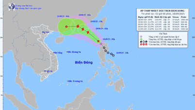
The National Center for Hydro-Meteorological Forecasting said that in the next 24 hours, the low pressure area in the central East Sea will move in a West-Northwest direction, traveling about 15km per hour and is likely to strengthen into a typhoon. tropical depression
According to the Department of Hydrometeorology, the probability of a low pressure area strengthening into a tropical depression fluctuates between 60-70%, and the probability of strengthening into a storm is below 10%.
During the last 10 days of September, there is a high possibility of 1-2 storms forming in the sea east of the Philippines. strong storm and may enter the East Sea, affecting our mainland. The hydrometeorological forecasting agency is monitoring and will inform 3-5 days in advance when there are signs of a storm forming.
Influence of low pressure circulation, which may later strengthen into a tropical depression, the central East Sea area will have heavy showers and thunderstorms, winds will gradually increase to level 5, sometimes level 6, gusting to level 8, waves 2-3m high, rough seas.

Forecasting further in the next 6 months (from October 2025 to March 2026), the meteorological agency said that ENSO is likely to remain neutral and lean towards the cold phase, but has not yet reached a La Nina cycle.
In the last three months of 2025 (October-December), storms and tropical depressions operating in the East Sea and affecting our country may be higher than the average of many years (average of many years in the East Sea 4.5 storms, 1.9 storms making landfall). From January to March 2026, there is little possibility of storms and tropical depressions appearing in this sea area.
From October to November 2025, moderate and heavy rains are likely to occur in the Central region, concentrated in Ha Tinh to Hue and the eastern region of the provinces from Quang Ngai to Khanh Hoa. From January to March 2026, there is a possibility of some showers and thunderstorms in the Central region. In the first months of 2026, the South may experience unseasonal rains.
Cold air is likely to appear from the end of September, with weak intensity and unstable activity. From November 2025 to February 2026, cold air is strong, gradually decreasing from March.
"Severe cold in the North may appear from the second half of December, increasing in January-February 2026, equivalent to the average of many years", Meteorological agency commented.
From November to December 2025, the average temperature across the country tends to be about 0.5°C lower than the average of many years in the same period. From January to March 2026, the temperature is generally similar to many years.
Source: https://baolangson.vn/cuoi-thang-9-bien-dong-co-the-don-1-2-con-bao-manh-5059038.html
![[Photo] Science and Technology Trade Union honors exemplary workers and excellent union officials](https://vphoto.vietnam.vn/thumb/1200x675/vietnam/resource/IMAGE/2025/9/17/842ff35bce69449290ec23b75727934e)


![[Photo] General Secretary To Lam chairs a working session with the Standing Committee of the Government Party Committee](https://vphoto.vietnam.vn/thumb/1200x675/vietnam/resource/IMAGE/2025/9/17/cf3d855fdc974fa9a45e80d380b0eb7c)


Comment (0)