
The National Center for Hydro-Meteorological Forecasting said that at 1:00 a.m. on December 18, the center of storm Jelawat was in the sea southeast of the southern Philippines. The strongest wind near the center of the storm was level 8 (62-74 km/h), gusting to level 10, moving west at about 20 km/h.
Forecast by 1:00 a.m. on December 19, the storm is forecast to be in the sea northwest of the southern Philippines and change direction, moving west northwest at a speed of about 25 km/h and weakening into a tropical depression. The strongest wind near the storm center is level 7, gusting to level 9.
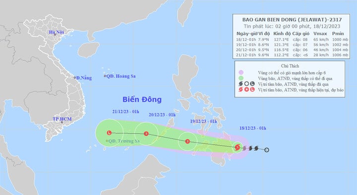
Path of typhoon Jelawat.
At around 1am on December 20, the tropical depression moved in a West-Northwest direction at a speed of 20-25km/h, entering the East Sea, about 320km southeast of Song Tu Tay Island. The strongest wind near the center of the depression was at level 6, gusting to level 8, then gradually weakening.
On land, today (December 18), the northern provinces continue to experience severe cold, and the mountainous areas are extremely cold. The observed temperature at 6am on the same day was generally at 11-14 degrees Celsius. Of which, Dien Bien was 16.6 degrees Celsius, Ha Dong ( Hanoi ) was 14.1 degrees Celsius, and some localities had temperatures below 10 degrees Celsius, including: Sa Pa (Lao Cai) 6.4 degrees Celsius; Cao Bang 9.2 degrees Celsius; Mau Son (Lang Son) 7.6 degrees Celsius.
It is forecasted that at 7-8am, the temperature in the North will increase by about 0.5-1 degree Celsius.
In addition, on December 18, Quang Tri to Khanh Hoa will have rain, moderate rain, locally heavy rain and thunderstorms with rainfall of 15-30mm, some places over 60mm. From the night of December 18, the rain will gradually decrease.
Thunderstorms may produce tornadoes, lightning, hail and strong gusts of wind. Localized heavy rain may cause flooding in low-lying areas.
The meteorological agency warns that in the next 6 hours, there is a high risk of flash floods on small rivers and streams, and landslides on steep slopes in many districts. Specifically:
Quang Tri : Huong Hoa, Dakrong, Trieu Phong, Gio Linh, Vinh Linh.
Thua Thien Hue: A Luoi, Nam Dong, Huong Tra town, Huong Thuy, Phong Dien.
Da Nang: Hoa Vang, Lien Chieu.
Quang Nam: Bac Tra My, Nam Tra My, Dai Loc, Dong Giang, Duy Xuyen, Hiep Duc, Nam Giang, Nong Son, Nui Thanh, Phuoc Son, Que Son, Tay Giang, Tien Phuoc.
Quang Ngai: Ba To, Son Ha, Son Tay, Tra Bong.
Video: Weather forecast for December 18
Nguyen Hue
Source


![[Photo] Nghe An: Provincial Road 543D seriously eroded due to floods](https://vphoto.vietnam.vn/thumb/1200x675/vietnam/resource/IMAGE/2025/8/5/5759d3837c26428799f6d929fa274493)


Comment (0)