
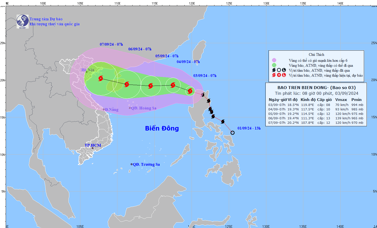
According to the National Center for Hydro-Meteorological Forecasting, this morning (September 3), storm YAGI entered the northeastern sea of the North East Sea, becoming storm number 3 in 2024.
At 7:00 a.m., the center of the storm was at approximately 18.4 degrees North latitude; 119.8 degrees East longitude, in the northeastern sea area of the North East Sea. The strongest wind near the center of the storm was level 8 (62-74 km/h), gusting to level 11, moving in the West Northwest direction, at approximately 20-25 km/h.
The National Center for Hydro-Meteorological Forecasting predicts that in the next 2 days, storm No. 3 will continue to increase in intensity, possibly reaching level 13, gusting to level 16 when entering the sea area east of Hainan Island (China). According to current forecasts, there is a high possibility that the storm will enter the Gulf of Tonkin around the afternoon to evening of Friday (September 6), then it is expected to approach the coastal provinces of the North and North Central regions from Saturday (September 7).
Direction of movement of storm YAGI - storm number 3. Photo: nchmf
Storm YAGI - how strong is storm number 3?
Currently, the forecast bulletins for storm YAGI - storm number 3 all agree that this could be a strong storm. Specifically, according to the National Center for Hydro-Meteorological Forecasting, by 7:00 a.m. on September 4, storm number 3 was moving in the West-Northwest direction, at a speed of about 10 km/h, storm intensity level 9-10, gust level 12.
At 7:00 a.m. on September 5, storm No. 3 moved westward at a speed of about 10 km/h, storm intensity level 11-12, gust level 14.
At 7:00 a.m. on September 6, storm No. 3 moved westward at a speed of about 10 km/h, storm intensity level 13, gust level 16.
Forecast of the impact of storm YAGI - storm number 3
From September 3, the northeastern sea area of the North East Sea will gradually increase to level 6, near the storm center it will increase to level 8-9, gusting to level 11-12; rough seas. It is forecasted that from September 4-6, storm YAGI may reach a very strong storm level in the northeastern East Sea area, with maximum winds reaching level 12-13, gusting to level 16 near the storm center.
In the next 24 hours, the eastern sea of the North East Sea will have waves 2.0-4.0m high, near the storm center 3.0-5.0m. After that (September 4-6), they may increase to 5-7m. The sea will be rough and very dangerous for ships.
Source: https://danviet.vn/nong-bao-yagi-da-vao-bien-dong-tro-thanh-con-bao-so-3-cuong-do-con-tang-nguy-co-giat-cap-16-20240903075537352.htm


![[Maritime News] Two Evergreen ships in a row: More than 50 containers fell into the sea](https://vphoto.vietnam.vn/thumb/402x226/vietnam/resource/IMAGE/2025/8/4/7c4aab5ced9d4b0e893092ffc2be8327)


Comment (0)