According to Mr. Hoang Phuc Lam, Deputy Director of the National Center for Hydro-Meteorological Forecasting, as of 8:00 p.m. tonight, July 23, the tropical depression in the East Sea has strengthened into a storm, with the international name Comay (Comay - 1 of 10 storm names proposed by Vietnam in the list of storm names of the Asia- Pacific Regional Storm Committee). This is the 4th storm in the East Sea in 2025.
Earlier, on the afternoon of July 23, Deputy Minister of Agriculture and Environment Nguyen Hoang Hiep signed an urgent dispatch to coastal provinces and cities from Quang Ninh to Dak Lak requesting them to be ready to respond to the tropical depression that has just appeared in the East Sea.
At noon on July 23, a new tropical depression appeared in the sea northwest of Luzon Island (Philippines). Updated to the afternoon of July 23, the tropical depression has entered the sea east of the North East Sea. The center of the tropical depression is at about 18 degrees North latitude - 119.7 degrees East longitude. The strongest wind is level 6-7, gusting to level 9, moving in the West Southwest direction at a speed of 10-15km/hour.
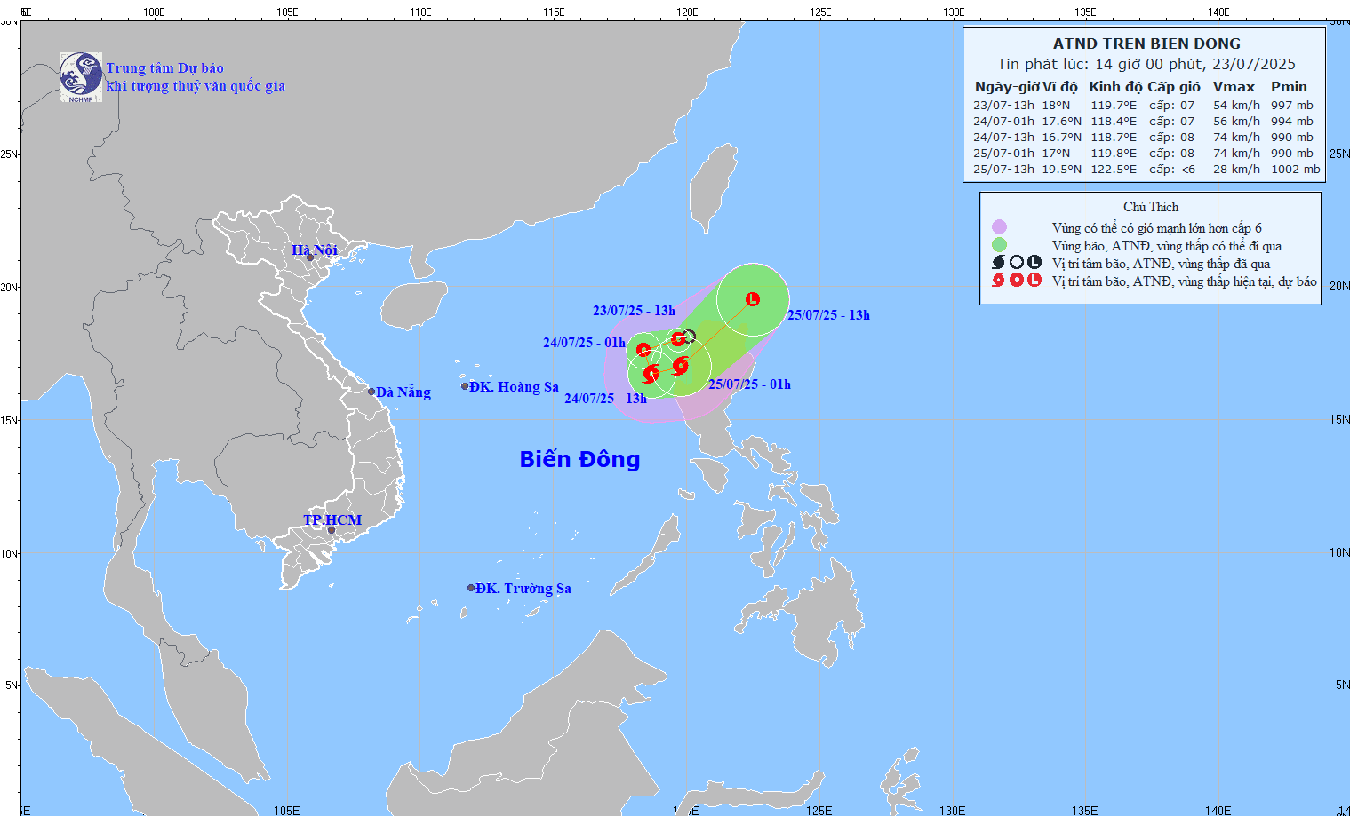
The National Center for Hydro-Meteorological Forecasting said that the tropical depression will strengthen into a storm (July 24). However, this cyclone system has a tendency to continuously change direction and move out of the East Sea. According to Mr. Hoang Phuc Lam, Deputy Director of the National Center for Hydro-Meteorological Forecasting, this tropical depression (storm) may not affect the mainland of Vietnam.
However, the eastern sea of the North East Sea will have strong winds of level 6-7, near the storm center will have strong winds of level 8, gusting to level 10. The sea will be rough, very dangerous for ships.
In the face of consecutive natural disasters, the dispatch of the Ministry of Agriculture and Environment clearly stated: Localities need to promptly notify captains, ship owners, and fishermen of the location, direction of movement, and dangerous areas of the tropical depression so that they can proactively take shelter. The dangerous area in the next 12 hours is determined from latitude 16 to 19.5 degrees North and east of longitude 116.5.
The Ministry of Agriculture and Environment also requested that rescue forces be ready, and asked media agencies to increase reporting so that people and local authorities are not subjective.
Source: https://www.sggp.org.vn/bao-so-4-tien-vao-bien-dong-co-ten-quoc-te-comay-post805126.html










![[Photo] National Assembly Chairman attends the seminar "Building and operating an international financial center and recommendations for Vietnam"](https://vphoto.vietnam.vn/thumb/1200x675/vietnam/resource/IMAGE/2025/7/28/76393436936e457db31ec84433289f72)







Comment (0)