

 |
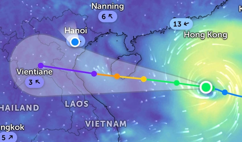
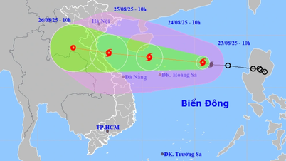
| Current location of storm number 5. (Zoom Earth photo) |
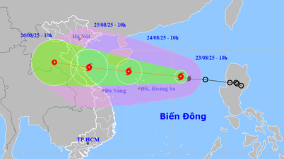
At 7:00 a.m., the center of the storm was at approximately 17.2 degrees North latitude; 116.6 degrees East longitude, approximately 480 km East Northeast of Hoang Sa special zone. The strongest wind near the center of the storm was level 8 (62-74 km/h), gusting to level 10; moving in a West Northwest direction at a speed of approximately 25 km/h.
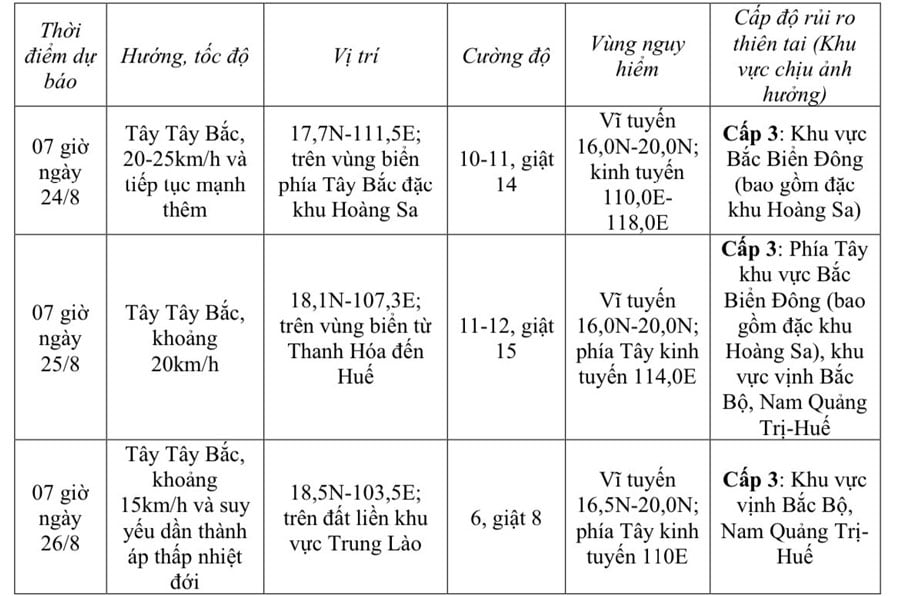 |
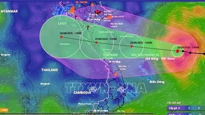
| Storm forecast (next 24 to 72 hours). |
At sea, in the North East Sea area (including Hoang Sa special zone), there are strong winds of level 8-9, near the storm center of level 10-11, gusts of level 14, waves 4-6m high, rough seas.
From the afternoon of August 24, the sea area from Thanh Hoa to Hue (including Con Co and Hon Ngu special zones) will have winds gradually increasing to level 6-8, then increasing to level 9-10, near the storm's eye level 11-12, gusting to level 15; waves 4-6m high, near the eye 6-8m. The sea will be very rough.
From the night of August 24, the northern sea area of Bac Bo Gulf (including Bach Long Vi special zone) will have winds gradually increasing to level 6-7, gusting to level 9, with waves 2-3m high. Rough seas.
Storm surge and coastal flooding warning: The coastal area of Thanh Hoa-Quang Tri has storm surge from 0.5-1.0m high. Water level in Sam Son (Thanh Hoa) is 3.2-3.6m high, in Hon Ngu (Nghe An) is 3.3-3.7m high, in Vung Ang ( Ha Tinh ) is 3.1-3.4m high and in Cua Gianh (Quang Tri) is 1.7-2m high.
At sea, coastal areas during storms are extremely dangerous, unsafe for any means of transport or construction operating in the danger zone such as: tourist boats, passenger ships, transport ships, cages, rafts, aquaculture areas, dykes, embankments, coastal routes. Vehicles are highly likely to capsize, be destroyed, or be flooded due to strong winds, big waves, and rising sea levels.
On land from the night of August 24, on land from Thanh Hoa to Quang Tri, winds will gradually increase to level 7-9, near the storm center level 10-12, gusting to level 14.
From the night of August 24 to the end of August 26, in the Northern Delta region and Thanh Hoa to Hue, there is a possibility of widespread heavy rain with common rainfall of 100-150mm, locally over 250mm, especially in the Thanh Hoa to Quang Tri region, there will be heavy to very heavy rain with common rainfall of 150-300mm, locally over 600mm.
Warning of risk of heavy rain (>200mm/3 hours).
From August 25 to August 26, in the capital Hanoi and Da Nang City, there will be moderate rain, heavy rain and thunderstorms; in the Ho Chi Minh City area, there will be rain, showers and thunderstorms in the late afternoon and evening. During thunderstorms, be on guard against the risk of tornadoes and strong gusts of wind.
Source: https://baothainguyen.vn/tin-moi/202508/ap-thap-nhiet-doi-manh-len-thanh-bao-so-5-02f33de/


![[Photo] General Secretary To Lam attends the 80th Anniversary of the Cultural Sector's Traditional Day](https://vphoto.vietnam.vn/thumb/1200x675/vietnam/resource/IMAGE/2025/8/23/7a88e6b58502490aa153adf8f0eec2b2)


Comment (0)