
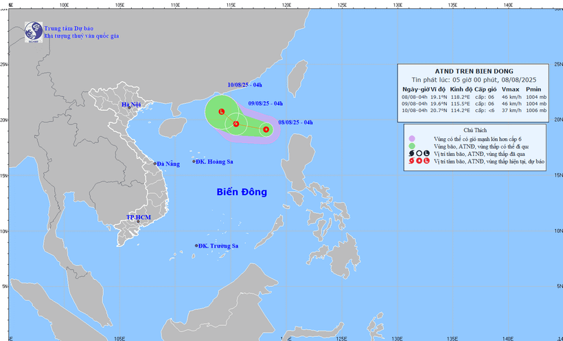
Map of forecasted trajectory and intensity of tropical depression at 5:00 a.m. August 8, 2025. (Photo: National Center for Hydro-Meteorological Forecasting)
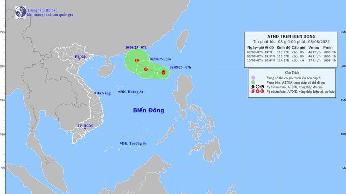
According to the National Center for Hydro-Meteorological Forecasting, early this morning (August 8), the low pressure area in the northern East Sea has strengthened into a tropical depression.
At 4:00 a.m., the center of the tropical depression was at about 19.1 degrees north latitude; 118.2 degrees east longitude, in the sea east of the northern East Sea. The strongest wind near the center of the tropical depression was level 6 (39-49 km/h), gusting to level 8; moving west-northwest at a speed of about 10-15 km/h.
It is forecasted that by 4:00 a.m. on August 9, the tropical depression will continue to move west-northwest, at a speed of 10-15 km/hour, with the center of the depression at about 19.6 degrees north latitude; 115.5 degrees east longitude; about 560 km northeast of Hoang Sa archipelago. The strongest wind near the center of the depression is level 6, gusting to level 8, affecting the northeastern sea area of the northern East Sea.
At 4:00 a.m. on August 10, the tropical depression is expected to move northwest at a speed of about 5-10 km/hour and gradually weaken into a low pressure area over the northwest sea of the northern East Sea.
Due to the influence of the tropical depression, at sea, the northeastern sea area of the northern East Sea has thunderstorms and strong winds of level 6, gusting to level 8, rough seas. Waves are 2-3m high. Ships operating in the above-mentioned dangerous areas are likely to be affected by thunderstorms, whirlwinds, strong winds, and large waves.
Nhandan.vn
Source: https://nhandan.vn/ap-thap-nhiet-doi-manh-cap-6-giat-cap-8-vua-hinh-thanh-tren-bien-dong-post899353.html


![[Photo] Discover the "wonder" under the sea of Gia Lai](https://vphoto.vietnam.vn/thumb/1200x675/vietnam/resource/IMAGE/2025/8/6/befd4a58bb1245419e86ebe353525f97)


Comment (0)