

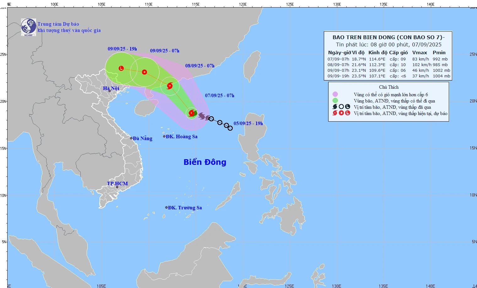
Map of forecast path and intensity of storm No. 7 at 8:00 a.m. on September 7, 2025.
At 7:00 a.m. on September 7, the storm center was at approximately 18.7 degrees North latitude - 114.6 degrees East longitude, in the northern part of the East Sea. The strongest wind near the storm center was level 9 (75-88 km/h), gusting to level 11.
Forecast by 7am tomorrow, September 8, the storm center is at about 21.6 degrees North latitude - 112.3 degrees East longitude, in the sea area south of Guangdong province (China). Intensity level 10, gust level 13. Risk warning level 3 in the sea area north of the East Sea.
At 7:00 a.m. on September 9, the storm center was at about 23.1 degrees North latitude - 109.6 degrees East longitude, on the mainland of Guangdong province (China). Intensity level 6, gust level 8. Risk warning level 3 in the northwest sea of the East Sea.
At 7:00 p.m. on September 9, the center of the storm was located at 23.5 degrees North latitude - 107.1 degrees East longitude, on the mainland of Guangxi Province (China). The intensity has now decreased to below level 6, weakening into a low pressure area.
NM
Source: https://baothanhhoa.vn/trong-3-gio-qua-bao-so-7-it-dich-chuyen-260784.htm


![[Photo] Prime Minister Pham Minh Chinh chairs the 20th meeting of the Steering Committee for important national projects and works](https://vphoto.vietnam.vn/thumb/1200x675/vietnam/resource/IMAGE/2025/9/10/e82d71fd36eb4bcd8529c8828d64f17c)

![[Photo] President Luong Cuong hosts state reception for Governor-General of Australia](https://vphoto.vietnam.vn/thumb/1200x675/vietnam/resource/IMAGE/2025/9/10/a00546a3d7364bbc81ee51aae9ef8383)
![[Photo] Giant pipeline leading water to West Lake, contributing to reviving To Lich River](https://vphoto.vietnam.vn/thumb/1200x675/vietnam/resource/IMAGE/2025/9/10/887e1aab2cc643a0b2ef2ffac7cb00b4)


Comment (0)