

The Ba River is a large river in the South Central region, originating from Ngoc Ro Mountain in Kon Tum Province (formerly), at an altitude of 1,549 m above sea level. The Ba River is 388 km long, flowing through three provinces: Kon Tum, Gia Lai and Phu Yen (formerly) - now Quang Ngai, Gia Lai and Dak Lak provinces. The river flows into the East Sea at Da Dien estuary in Tuy Hoa ward.
The Hinh River is a large tributary of the Ba River, originating from the top of Chohomu Mountain in Dak Lak Province, at an altitude of 2,051 m above sea level, with a tributary of 1,040 km2 , with a length of 88 km, merging with the Ba River in Son Hoa Commune.
Along the banks of the Ba and Hinh rivers are vast forests, lakes, dams, and rice fields, bringing prosperity to hundreds of villages and feeding millions of people. Today, along National Highway 19 and National Highway 25, on both banks of the Ba River, urban areas, industrial parks, and factories have been and are being formed, creating new urban spaces for Dak Lak province.
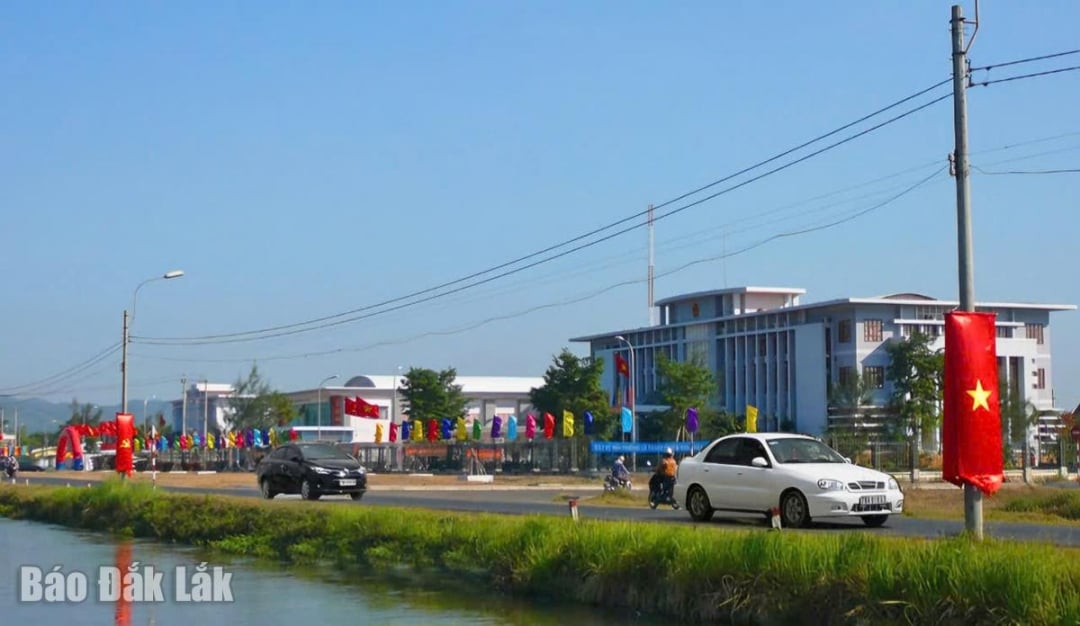 |
| Phu Thu town (former Tay Hoa district, now the center of Tay Hoa commune) is one of the urban areas along the Ba river with complete basic traffic infrastructure. Photo: Le Thanh |
National Highway 19 on the southern bank of the Ba River, connecting Phu Yen (old) with Dak Lak (old), is 188 km long; in Phu Yen, 109 km long, there are urban areas (according to the old place names): Dong Hoa town (starting point), Phu Thu district town, Son Thanh Dong town, Hai Rieng district town, Tan Lap town. Through the territory of Dak Lak province (old), 89 km long, there are Ea Kar and M'Drak urban areas. Thus, along National Highway 19, Dak Lak province has 7 "ladder" urban areas on the banks of the Ba River.
National Highway 25 on the northern bank of the Ba River to Gia Lai has the following urban areas: Tuy Hoa (starting point), Phu Hoa town, Hoa Hoi town, Cung Son town (old name). Through Gia Lai territory there are the following urban areas: Ayun Pa, Chu Puh and Chu Se (end point). Thus, along National Highway 25 to Gia Lai there are also 7 step-level urban areas on the banks of the Ba River, of which 4 are in the territory of Dak Lak province (old). Thus, along both banks of the Ba River through Dak Lak province there are a total of 11 urban areas.
Most of the urban areas along the Ba River are small in scale, many of which have existed for a long time, such as Son Hoa and Ayun Pa. Urban areas established after the country's liberation (1975) such as Song Hinh, Tay Hoa, and Phu Hoa 1 are old district towns and sub-regional towns. Currently, these urban areas are the centers of newly established communes, so the nature, functions, and tasks of the urban areas are no longer the same as before, because there is no longer a district-level government.
To create conditions for the new Dak Lak province to develop, along with upgrading National Highway 19 and National Highway 25, it is necessary to soon plan and invest in developing the infrastructure of the urban chain on both sides of the Ba River. Exploiting land along the riverbank must go hand in hand with investing in urban infrastructure, forming residential and service areas because these are urban steps that create new spaces and new corridors for Dak Lak province. Only then will the Ba River truly become a corridor for economic and social development along the East-West axis, connecting the great forest with the ocean.
Architect .
Source: https://baodaklak.vn/kinh-te/202509/phat-trien-chuoi-do-thi-doc-song-ba-f46183b/

![[Photo] Launching Ceremony of the Specialized Electronic Information Page of the Communist Party of Vietnam - 14th Congress](https://vphoto.vietnam.vn/thumb/1200x675/vietnam/resource/IMAGE/2025/9/12/4c1b894be2ea4e3daccfd8c038b6fb46)
![[Photo] General Secretary To Lam attends the launching ceremony of the website of the Communist Party of Vietnam - 14th National Congress](https://vphoto.vietnam.vn/thumb/1200x675/vietnam/resource/IMAGE/2025/9/12/0d4fce7dbce2409cb3c03c21fdf3c3b5)

![[Photo] Thac Ba Lake: Towards an international-class tourism, resort and cultural center by 2040](https://vphoto.vietnam.vn/thumb/1200x675/vietnam/resource/IMAGE/2025/9/12/0940443efe0a427b88707caadba1cc41)


![[Photo] Where the history of resistance comes alive with modern technology at "95 years of the Party Flag lighting the way"](https://vphoto.vietnam.vn/thumb/1200x675/vietnam/resource/IMAGE/2025/9/12/81c1276f52b849c8b16e2d01dd1c85e4)


Comment (0)