

The meteorological agency said that today, storm No. 7 will make landfall in mainland China and gradually weaken. On September 9-10, the mountainous and midland areas of the North are likely to experience widespread heavy rain, with some places experiencing over 300mm.
On the morning of September 8, the National Center for Hydro-Meteorological Forecasting said that storm Tapah (storm number 7) is active in the northwest sea area of the North East Sea.
The strongest wind near the storm center is level 10-11 (89-117km/h), gusting to level 13 and moving in the North-Northwest direction, traveling about 20-25km per hour.
It is forecasted that around noon to afternoon today, the storm will make landfall in Guangdong province (China) with a level 8 intensity, gusting to level 10 and will gradually weaken into a tropical depression.
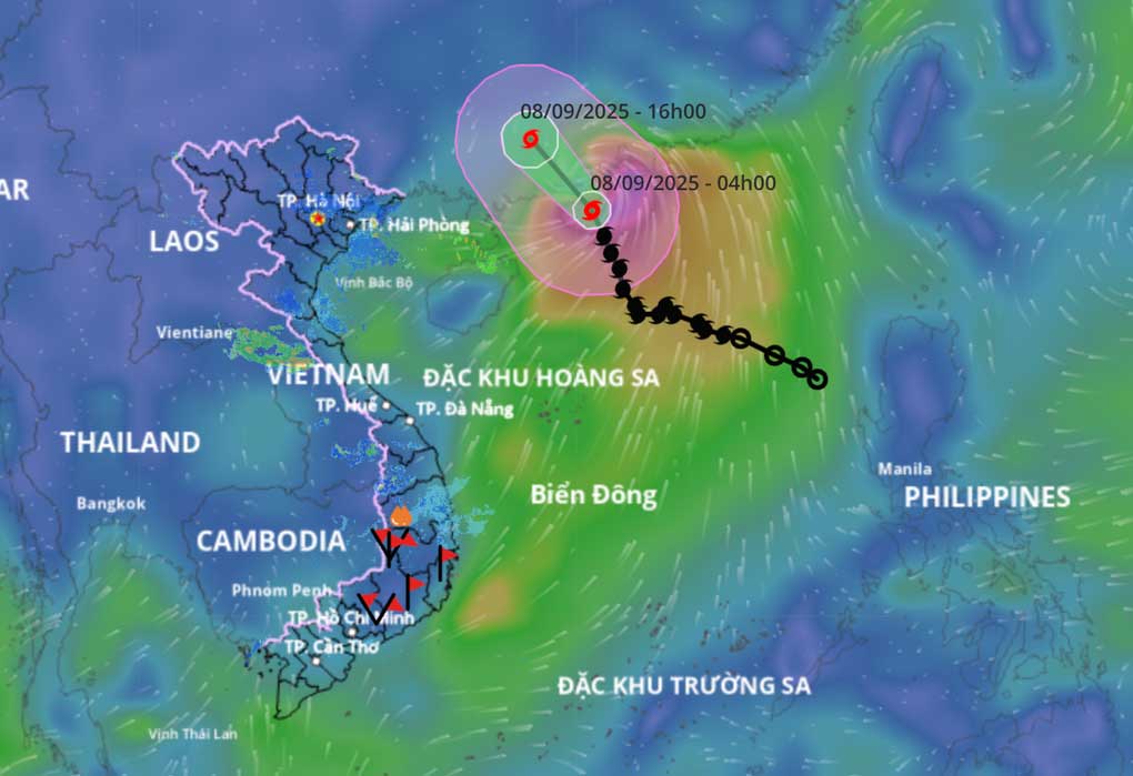 |
| Typhoon No. 7 will make landfall in mainland China today (Photo: Disaster monitoring system). |
Due to the influence of the storm, the northwestern sea area of the North East Sea has strong winds of level 7-8, near the storm center strong winds of level 9-11, gusts of level 13, waves 4-6m high, and rough seas.
Ships operating in the above mentioned dangerous areas are likely to be affected by storms, whirlwinds, strong winds and large waves.
The hydro-meteorological agency said that although not directly affected by the storm's circulation, areas on the far edge of the storm's circulation such as the Gulf of Tonkin and the eastern coastal areas of the North may experience thunderstorms, whirlwinds and strong gusts of wind.
According to forecasts, from the afternoon and night of September 9 to September 11, the post-storm circulation of storm No. 7 will cause widespread heavy rain in the North, focusing on the midland and mountainous areas of the Northeast.
The hydrometeorological agency said that from September 9 to the night of September 10, the mountainous and midland areas of the North are likely to experience widespread heavy rain, with rainfall ranging from 70-150mm, and locally over 300mm.
The agency warns of the risk of heavy rain of over 100mm/3 hours. Thunderstorms are likely to cause tornadoes, lightning, hail and strong gusts of wind.
Heavy rain can cause flooding in low-lying areas, urban and industrial areas; flash floods on small rivers and streams, and landslides on steep slopes.
According to Bach An/ dantri.com.vn
Source: https://baovinhlong.com.vn/thoi-su/202509/bao-tapah-tang-cap-va-di-chuyen-nhanh-mien-bac-sap-mua-to-f71065e/
![[Photo] General Secretary To Lam chaired the Politburo's working session with the Standing Committees of Party Committees of Central Party agencies.](https://vphoto.vietnam.vn/thumb/1200x675/vietnam/resource/IMAGE/2025/9/9/8343386e1e8f43c6a3c0543da7744901)
![[Photo] Cambodia's Techo International Airport Officially Opens](https://vphoto.vietnam.vn/thumb/1200x675/vietnam/resource/IMAGE/2025/9/9/330836bb28ad4ee4bdd512cc1a2d0849)


![[Photo] Politburo works with the Standing Committees of Vinh Long and Thai Nguyen Provincial Party Committees](https://vphoto.vietnam.vn/thumb/1200x675/vietnam/resource/IMAGE/2025/9/8/4f046c454726499e830b662497ea1893)


Comment (0)