

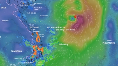
 movement direction according to the model of the National Center for Hydro-Meteorological Forecasting")
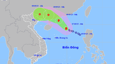
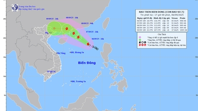
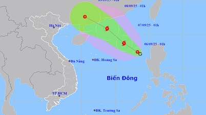
Early morning of September 6, the center of the tropical depression was at about 17.4 degrees North latitude - 118.3 degrees East longitude, in the eastern sea area of the North East Sea. The tropical depression is strong level 6 (39-49km/h), gusting to level 8, moving northwest at a speed of about 10km/h.
It is forecasted that in the next 24 hours, the tropical depression will continue to move in the northwest direction, and may strengthen into a storm when it is about 500km east-northeast of the Hoang Sa archipelago. At this time, the wind speed will increase to level 8, gusting to level 10. The dangerous area in the East Sea is determined between latitudes 16 and 20 and longitudes 114.5 and 120.
The meteorological agency forecasts that from the morning of September 8, the storm will continue to move northwest, faster at a speed of 15km/hour. The storm center is in the northern sea area of the North East Sea, with a strength of level 9, gusting to level 11.
In the next 48-72 hours, the storm will change direction to move west-northwest, traveling about 15km per hour. According to the model of the National Center for Hydro-Meteorological Forecasting, the storm's eye may head towards Guangdong province and Leizhou peninsula (China). However, the storm will cause dangerous weather in the North East Sea.
At sea, the Northeast of the East Sea has strong winds of level 6, then increasing to level 7-8, gusting to level 10, waves 2-4m high, rough seas. Ships operating in the dangerous area are at risk of being affected by storms, whirlwinds, strong winds and big waves.
Source: https://www.sggp.org.vn/ap-thap-nhiet-doi-co-kha-nang-manh-len-thanh-bao-tren-bien-dong-post811825.html
![[Photo] General Secretary To Lam attends the 80th Anniversary of the General Staff of the Vietnam People's Army](https://vphoto.vietnam.vn/thumb/1200x675/vietnam/resource/IMAGE/2025/9/6/126697ab3e904fd68a2a510323659767)
![[Photo] Prime Minister Pham Minh Chinh attends the 80th Anniversary of the Vietnam Posts and Telecommunications Group](https://vphoto.vietnam.vn/thumb/1200x675/vietnam/resource/IMAGE/2025/9/6/39a89e5461774c2ca64c006d227c6a4e)


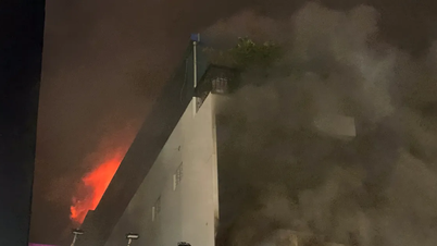
![[Photo] Rescuing people in flooded areas at the foot of Prenn Pass overnight](https://vphoto.vietnam.vn/thumb/1200x675/vietnam/resource/IMAGE/2025/9/6/19095b01eb844de98c406cc135b2f96c)
![[Photo] 80th Anniversary of the General Staff of the Vietnam People's Army](https://vphoto.vietnam.vn/thumb/1200x675/vietnam/resource/IMAGE/2025/9/6/49153e2a2ffc43b7b5b5396399b0c471)


![[Photo] Many people directly experience beloved Uncle Ho and the General Secretaries](https://vphoto.vietnam.vn/thumb/1200x675/vietnam/resource/IMAGE/2025/9/6/2f4d9a1c1ef14be3933dbef3cd5403f6)


Comment (0)