

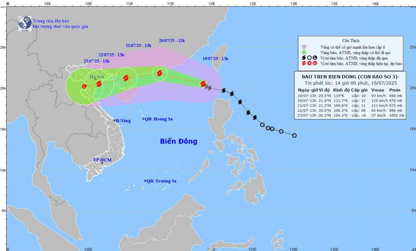
Location of storm center and expected path of storm No. 3. (Source: National Center for Hydro-Meteorological Forecasting)
On the morning of July 19, storm Wipha crossed the 120th meridian, entered the East Sea and became the 6th storm in the Northwest Pacific region and the 3rd storm in the East Sea.
According to the National Hydro-Meteorological Agency, storm number 3 is forecast to be a strong storm.
To learn more about the developments of storm No. 3, VNA reporters interviewed Associate Professor, Doctor, Director of the National Center for Hydro-Meteorological Forecasting Mai Van Khiem about this issue.
Here is the interview content:
- Can you tell us the current developments of storm number 3?
Dr. Mai Van Khiem: Currently, storm No. 3 is at level 9, up 1 level compared to the forecast in the past 24 hours. The storm is about 1,000km east of Leizhou Peninsula (China).
Forecasted to be a strong storm, moving fast (average about 20 km/h), with areas of heavy rain and strong winds, circulation shifting to the West and South.
International typhoon forecasting centers have a unified assessment of the trajectory but differ in intensity. Accordingly, typhoon No. 3 has the strongest intensity that can reach level 12-13, gusting to level 14-15 when in the eastern area of Leizhou Peninsula (China).
- It is forecasted to be a strong storm, so what issues should we pay attention to for storm number 3, sir?
Dr. Mai Van Khiem: The biggest and most dangerous risk in the next 24 hours is strong winds and big waves in the northern and central areas of the East Sea (Hoang Sa special zone); the northern sea area of the North East Sea is where the storm passes through, with wind intensity of level 10-12, gusts of level 15, waves 3-5m high, and 4-6m high near the storm center.
From around July 20-21, the special zones of Bach Long Vi, Co To, Cat Hai... are likely to be greatly affected by strong winds and heavy rains caused by storm No. 3.
Around early morning and on July 22, coastal waters from Quang Ninh to Thanh Hoa will begin to be directly affected by strong winds of level 7-9, heavy rain, rising water, and waves 3-5m high.
Large waves combined with high tides may cause flooding in low-lying areas along the coast of Quang Ninh - Hai Phong (from noon and afternoon on July 21-23).
On land, the impact of storm No. 3 is wide, affecting most of the Northeast region, some places in the Northwest, and the North Central provinces.
The provinces and cities directly affected by storm No. 3 will include Quang Ninh, Hai Phong, and coastal provinces of Hung Yen, Ninh Binh, and Thanh Hoa, which are forecast to be most severely affected by the storm.
Storm No. 3 is forecast to cause widespread heavy rain in the North and Thanh Hoa-Ha Tinh provinces; in which, in the midlands and the Northern Delta, Thanh Hoa, Nghe An, the rainy period from July 21-24, some places will have localized heavy rain with rainfall of over 150mm in 3 hours;
Flash floods and landslides on steep slopes in the mountainous regions of the North and Thanh Hoa and Nghe An.
- How was storm forecasting done and what recommendations do you have for storm response, sir?
Dr. Mai Van Khiem: On the afternoon of July 16, the National Center for Hydro-Meteorological Forecasting issued a tropical depression report near the East Sea; early in the morning of July 18, the National Center for Hydro-Meteorological Forecasting issued a storm report near the East Sea.
On the same day, the Ministry of Agriculture and Environment held a meeting to respond to storm Wipha (chaired by Deputy Minister Nguyen Hoang Hiep) with the participation of the Department of Hydrometeorology and the Department of Dyke Management and Disaster Prevention.
On the morning of July 19, the National Center for Hydro-Meteorological Forecasting and the Department of Hydro-Meteorological Forecasting issued storm information in the East Sea and held an internal online meeting on forecasting the developments and impacts of storm No. 3 on sea and land areas, early assessment of the flood situation caused by storm No. 3; reviewing preparations for forecasting and responding to storms...
To proactively respond to storms and minimize the risk of natural disasters caused by hydrometeorology, the hydrometeorological agency reminds people to regularly monitor forecast and warning information on the website of the National Center for Hydrometeorological Forecasting at nchmf.gov.vn, and provincial, municipal and regional hydrometeorological stations.
At the same time, regularly update the latest hydrometeorological forecast information on the official mass media of the Central and local levels to proactively respond, and at the same time recommend that the authorities in the affected localities pay attention to reviewing the flow bottlenecks and vulnerable locations in the area to take preventive measures.
Authorities and people in areas affected by the storm need to comply with the guidance and direction of the Ministry of Agriculture and Environment, the Department of Dyke Management and Natural Disaster Prevention and Control (Ministry of Agriculture and Environment), and provide timely and complete information to authorities at all levels and people to proactively prevent and respond.
Localities deploy shock forces to inspect and review residential areas along rivers, streams, and low-lying areas to proactively organize the relocation and evacuation of people in areas at high risk of deep flooding, flash floods, and landslides; organize forces ready to control and guide traffic, and place warning signs, especially through culverts, spillways, and areas with deep flooding and fast-flowing water; proactively arrange forces, materials, and means to overcome incidents, ensuring smooth traffic on main traffic routes when heavy rain, flash floods, and landslides occur...
- Sincerely thank Dr. Mai Van Khiem.
Source: VNA/Vietnam+
Source: https://baophutho.vn/bao-so-3-manh-di-chuyen-nhanh-hoan-luu-rong-khong-chu-quan-trong-ung-pho-236394.htm

![[Photo] Politburo works with the Standing Committees of Vinh Long and Thai Nguyen Provincial Party Committees](https://vphoto.vietnam.vn/thumb/1200x675/vietnam/resource/IMAGE/2025/9/8/4f046c454726499e830b662497ea1893)

![[Photo] Politburo works with the Standing Committees of Dong Thap and Quang Tri Provincial Party Committees](https://vphoto.vietnam.vn/thumb/1200x675/vietnam/resource/IMAGE/2025/9/8/3e1c690a190746faa2d4651ac6ddd01a)


![[Photo] Amazing total lunar eclipse in many places around the world](https://vphoto.vietnam.vn/thumb/1200x675/vietnam/resource/IMAGE/2025/9/8/7f695f794f1849639ff82b64909a6e3d)


Comment (0)