
The National Center for Hydro-Meteorological Forecasting has responded to public opinions and clearly explained the cause of this extreme weather phenomenon.
Severe thunderstorms due to super thunderstorm system combined with tropical convergence zone
According to the National Center for Hydro-Meteorological Forecasting, on the afternoon of July 19, the Northern region experienced widespread thunderstorms, with many places experiencing strong thunderstorms accompanied by tornadoes and gusts of wind. Strong winds were recorded at many stations: Cua Ong (Quang Ninh) gusting at 16m/s (level 7), Bai Chay (Quang Ninh) gusting at 26m/s (level 10), Bach Long Vi ( Hai Phong ) gusting at 18m/s (level 8).
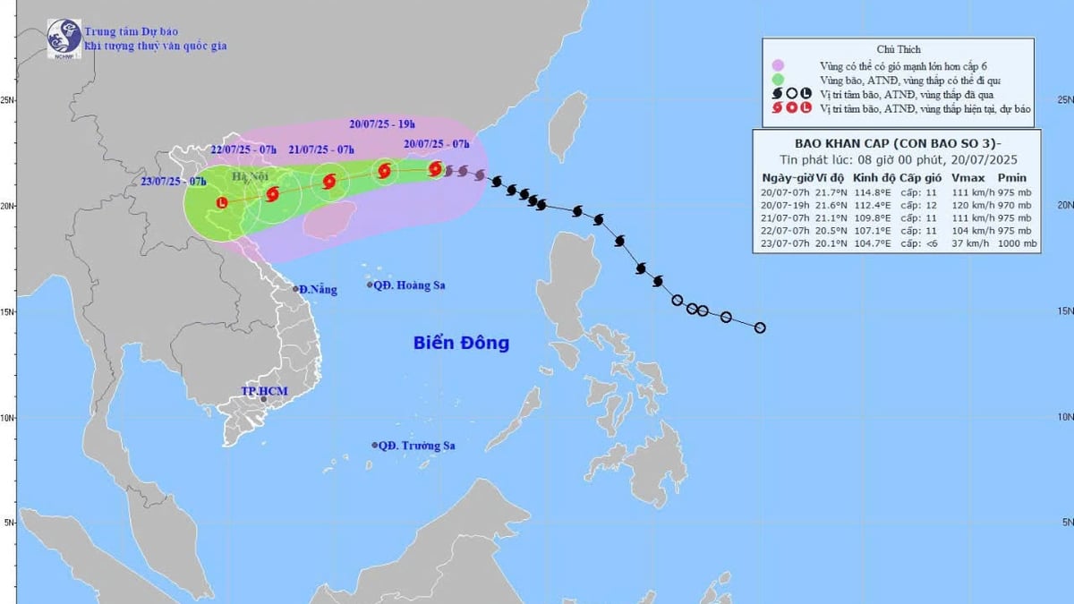
At the same time, the center of storm No. 3 was at about 20.7 degrees North latitude; 118.4 degrees East longitude, more than 1,000km east of Ha Long Bay. With a circulation of about 200km-300km, storm No. 3 has not directly affected the Gulf of Tonkin.
The cause of heavy rain and thunderstorms in the North and the Gulf of Tonkin is the impact of the tropical convergence zone passing through this area, combined with high temperatures for three consecutive days, creating strong updrafts in unstable atmospheric conditions. This phenomenon forms a super tropical thunderstorm system (Mesoscale Convective Systems – MCSs) capable of causing very heavy rain, accompanied by lightning, tornadoes, gusts of wind and other dangerous weather phenomena.
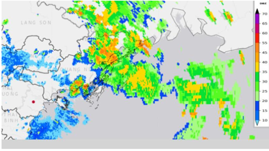
According to experts, a super thunderstorm system is a collection of many developing thunderstorm cloud clusters, with a diameter of several tens to several hundreds of kilometers, lasting for many hours, even up to 24 hours, stronger and more durable than a single thunderstorm. The Phu Lien radar response image at 13:30 on July 19 shows a strongly developing convective cloud area covering the Ha Long Bay area.
According to experts, a super thunderstorm system is a collection of many developing thunderstorm cloud clusters, with a diameter of several tens to several hundreds of kilometers, lasting for many hours, even up to 24 hours, stronger and more durable than a single thunderstorm. The Phu Lien radar response image at 13:30 on July 19 shows a strongly developing convective cloud area covering the Ha Long Bay area.
Meteorological Center: Timely warning issued

According to a quick report from the Steering Committee for Natural Disaster Prevention, Control and Search and Rescue of Quang Ninh province, at around 1:45 p.m. on July 19, the tourist boat QN7105 carrying 48 passengers and 5 crew members capsized due to a storm while visiting route 2 on Ha Long Bay. The accident location was determined to be between Hon Ga Choi and Nui Bai Tho, about 3 nautical miles from the mainland.
This unexpected and tragic incident has raised questions about the ability to forecast weather, especially in key tourist areas like Ha Long Bay. Some comments on social media said there was no clear warning of the storm.
In response to complaints from the public, the National Center for Hydro-Meteorological Forecasting confirmed that it had issued many early warning bulletins. Specifically, the first warning bulletin was issued by the Quang Ninh Provincial Hydro-Meteorological Station at 11:45 a.m. on July 19, based on weather radar images, clearly stating that convective clouds were developing and that there was a possibility of thunderstorms, tornadoes, and lightning in many areas, including Ha Long Ward.
The next warning bulletin was issued at 1:30 p.m. the same day, continuing to emphasize the risk of showers, thunderstorms, and strong gusts of wind in many communes and wards in the area. In addition, in the marine forecast bulletin issued at 3:30 p.m. on July 18, the station also predicted scattered showers and rough seas in the Bai Chay-Ha Long Bay sea area on July 19.
The National Center for Hydro-Meteorological Forecasting also issued a marine weather bulletin at 4:30 a.m. on July 19, predicting showers and thunderstorms in the Gulf of Tonkin, scattered thunderstorms at night, with the possibility of tornadoes and strong gusts of wind.
The Department of Hydrometeorology affirmed that it has directed its affiliated units to maintain stable operation of the monitoring and communication systems; update and promptly transmit bulletins to the Steering Committee for Natural Disaster Prevention and Control at all levels and the people through digital technology platforms and media.
Weather forecast for the coming days
It is forecasted that from the night of July 19 to July 21, due to the influence of storm No. 3, the northern East Sea, including the waters of Hoang Sa archipelago, will have storms and rain; the Gulf of Tonkin and the Gulf of Thailand will have scattered showers and thunderstorms.
From the night of July 20 to July 21, the northern sea area of the North East Sea will have strong winds of level 8-9, near the storm center level 10-12, gusting to level 15; waves 4m-6m high, rough seas. The northeastern sea area of the Gulf of Tonkin from July 21 will have winds gradually increasing to level 6-7, then increasing to level 8-9, near the storm center level 10-11, gusting to level 13; waves 2m-5m high, rough seas.
The National Center for Hydro-Meteorological Forecasting continues to closely monitor the developments of storm No. 3 and marine weather, ready to provide full and timely forecast and warning information to support the direction of natural disaster prevention and control and ensure safety for people.
NH (according to Nhan Dan)Source: https://baohaiphongplus.vn/ly-giai-nguyen-nhan-mua-dong-manh-tai-quang-ninh-va-bac-bo-416770.html


Comment (0)