
Storm forecast (in the next 24 to 72 hours):
Forecast time | Direction, speed | Location | Intensity | Danger zone | Disaster Risk Level (Region) bear the photo enjoy) |
07h/21/7 | Mainly West 20-25km/h | 21.1N-109.8E; on the mainland north of Leizhou Peninsula (China) Country) | Level 11, jerk level 14 | North latitude 20.0N; longitude 108.0E- 117.0E | Level 3: Northern sea area of the North East Sea, Eastern sea area Northern Gulf of Tonkin |
07h/22/7 | West Southwest, about 15km/h | 20.5N-107.1E; on the coastal area of Quang Ninh - Ninh Binh | Level 10- 11, jerk level 14 | North of latitude 19.5N; West of longitude 112.5E | Level 3: coastal waters Northwest of the North East Sea area, Gulf of Tonkin |
07h/23/7 | West Southwest, about 10km/h, weakening into a low pressure area | 20.1N-104.7E; on land in Upper Laos | < Level 6 | North of latitude 19.0N; West of longitude 109.5E | Level 3: Gulf of Tonkin waters. Coastal waters and mainland provinces from Quang Ninh to Thanh Hoa |
Due to the influence of storm No. 3, the northern sea area of the North East Sea has strong winds of level 8-10, near the eye of the storm, level 11-12, gusts of level 15; waves 5-7m high. The sea is very rough. From the night of July 20, the northern sea area of the Gulf of Tonkin (including the special zones of Bach Long Vi, Co To, Cat Hai) has winds gradually increasing to level 6-7, then increasing to level 8-9, near the eye of the storm, level 10-11, gusts of level 14; waves 2-4m high, near the eye, 3-5m. The sea is very rough.
From July 21, the sea in the southern Gulf of Tonkin will have winds gradually increasing to level 6-7, near the storm center level 8-9, gusting to level 11, waves 2-4m high. The sea is very rough. Ships/boats operating in the above-mentioned dangerous areas are likely to be affected by storms, whirlwinds, strong winds, and large waves.
The coastal area of Hai Phong - Quang Ninh has storm surges of 0.5-1m high, the water level at Hon Dau ( Hai Phong ) is 3.8-4.1m high, at Cua Ong (Quang Ninh) is 4.8-5.2m high. There is a high risk of flooding in low-lying coastal and river mouth areas at noon and afternoon on July 22.
From the evening and night of July 21, on the mainland from Quang Ninh to Thanh Hoa, winds will gradually increase to level 7-9, gusting to level 10-11; further inland, winds will increase to level 6-7, gusting to level 8-9; near the storm center, winds will increase to level 10-11, gusting to level 14.
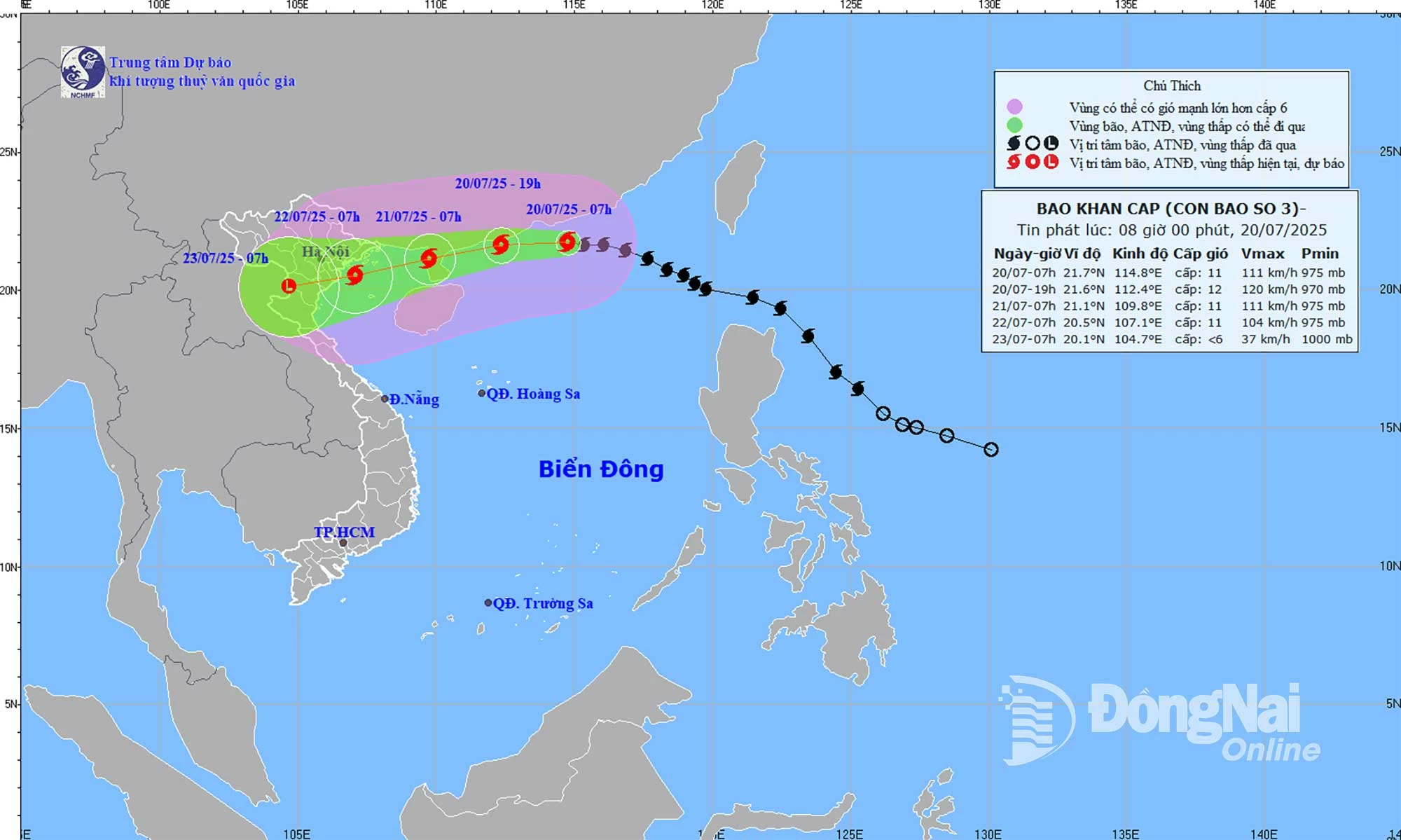 |
| Forecast map of storm No. 3's trajectory and intensity released at 8:00 a.m. on July 20. |
Storm No. 3 is not expected to directly affect the weather in Dong Nai province. The weather in Dong Nai is cloudy, with scattered showers and thunderstorms in the afternoon, evening and night, with moderate rain in some places and heavy rain in some places. During thunderstorms, beware of tornadoes, lightning and strong gusts of wind.
Kim Lieu
Source: https://baodongnai.com.vn/tin-moi/202507/cuong-do-bao-so-3-manh-cap-11-giat-cap-14-2f7028f/


![[Photo] National Assembly Chairman Tran Thanh Man visits Vietnamese Heroic Mother Ta Thi Tran](https://vphoto.vietnam.vn/thumb/1200x675/vietnam/resource/IMAGE/2025/7/20/765c0bd057dd44ad83ab89fe0255b783)


Comment (0)