
Typhoon WIPHA could become a strong, fast-moving, wide-ranging storm
According to the National Center for Hydro-Meteorological Forecasting, this morning (July 19), storm WIPHA entered the northeastern sea of the North East Sea, becoming storm number 3 in 2025.
At 7:00 a.m., the center of the storm was located at approximately 20.0 degrees North latitude; 119.8 degrees East longitude, in the northeastern sea area of the North East Sea. The strongest wind near the center of the storm was level 9 (75-88 km/h), gusting to level 12; moving northwest at a speed of approximately 20 km/h.
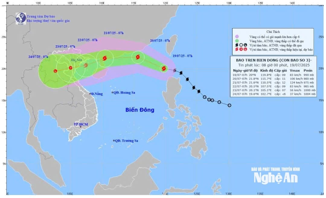
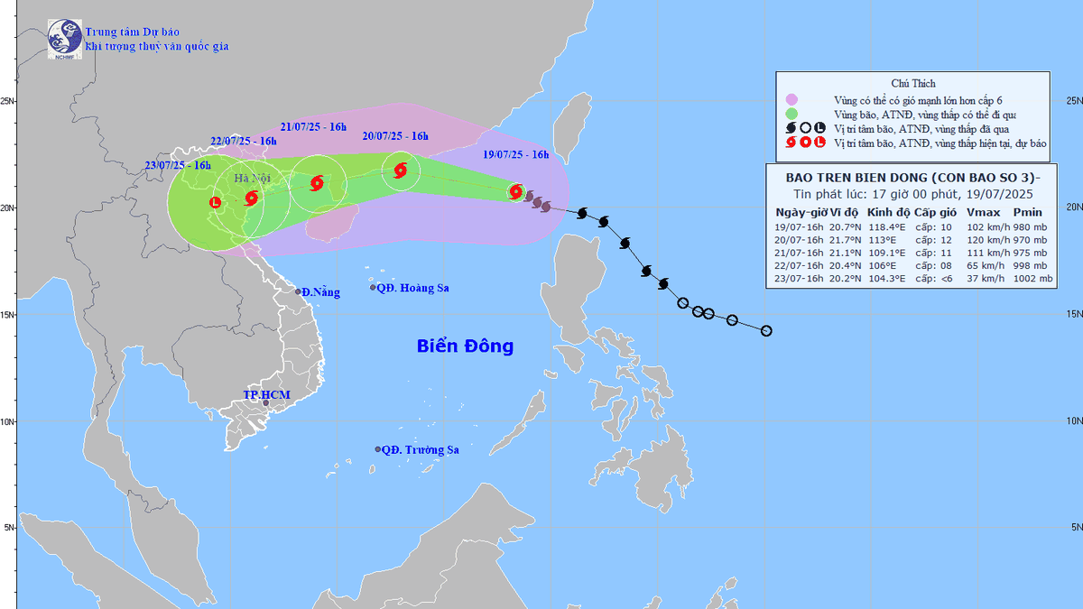
It is forecasted that the storm will enter the northern part of the Gulf of Tonkin around the evening and night of July 21 and may affect the Northern region on July 22. The current forecast model shows that the path and characteristics of storm WIPHA are quite similar to storm No. 3 - Yagi that occurred in 2024.
Localities in potentially affected areas need to proactively monitor the storm's developments closely and develop appropriate response plans, especially in the context of heavy rain that could last for many days.
What is worrying is that this storm is moving through the East Sea where the sea water temperature is very high, creating favorable conditions for the storm to increase in strength quickly and strongly.
In that context, typhoon WIPHA is assessed to be able to become a strong storm, moving quickly and having a wide area of influence. The sea area east of the North East Sea will gradually increase to level 6-7, the area near the storm's center will be level 8-9, then increase to 10-11, gusting to level 13; waves will be 4.0-6.0m high. The sea will be very rough.
Ships and boats operating in the above-mentioned dangerous areas are susceptible to the effects of storms, whirlwinds, strong winds, and large waves.
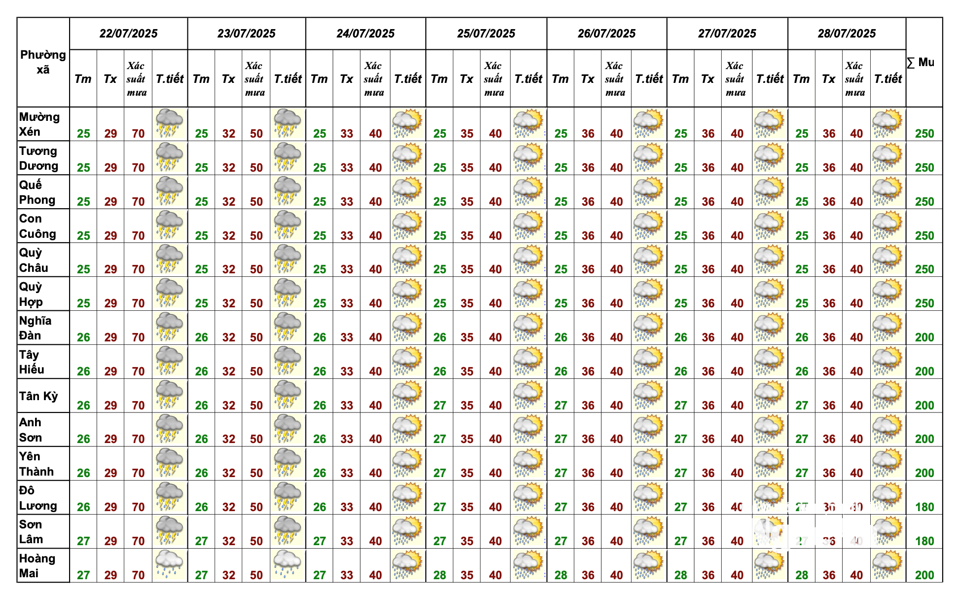
In Nghe An province, according to the provincial Hydrometeorological Station, from July 20 to 28, it is forecasted that there will be heavy and very heavy rain over a wide area. In particular, on July 22 and 23, it is forecasted that there will be very heavy rain accompanied by thunderstorms, lightning and strong gusts of wind that can affect agricultural production, cause trees to fall, damage houses, traffic works and infrastructure. In particular, note the wards and communes: Muong Xen, Tuong Duong, Que Phong, Con Cuong, Quy Chau, Quy Hop, Nghia Dan, Tay Hieu, Tan Ky, Anh Son, Yen Thanh, Do Luong, Son Lam, Hoang Mai.
Immediately deploy solutions to prevent landslides and flooding
Following the storm's developments, ministries and sectors have regularly directed affected localities to prepare response plans. The Ministry of Agriculture and Environment has held a meeting with localities to note that the storm's wind intensity is not too strong but the rain will be very heavy, so ministries, sectors and localities need to focus on guiding ships and boats to move out of the affected areas, ensuring safety in tourist areas and aquaculture areas.
In addition, reservoirs in the North are quite full, the Ministry of Agriculture and Environment has directed reservoir owners to carry out flood discharge, lower the water level of reservoirs to safe levels, and at the same time, require companies and units to ensure reservoir operation procedures, avoiding emergency situations like what happened at Thac Ba hydropower reservoir in 2024. The Deputy Minister requested localities to immediately deploy solutions to prevent landslides and flooding.

This is the first storm when the new two-level local government apparatus comes into operation, so it requires great initiative in localities, especially at the commune level, to proactively prevent and deploy measures early and from afar, ensuring safety for people and minimizing damage caused by the storm.
Source: https://baonghean.vn/canh-bao-bao-so-3-wipha-di-chuyen-nhanh-vung-anh-huong-rong-tu-ngay-20-7-co-mua-to-den-rat-to-o-cac-tinh-bac-bo-thanh-hoa-nghe-an-va-ha-tinh-10302618.html


Comment (0)