
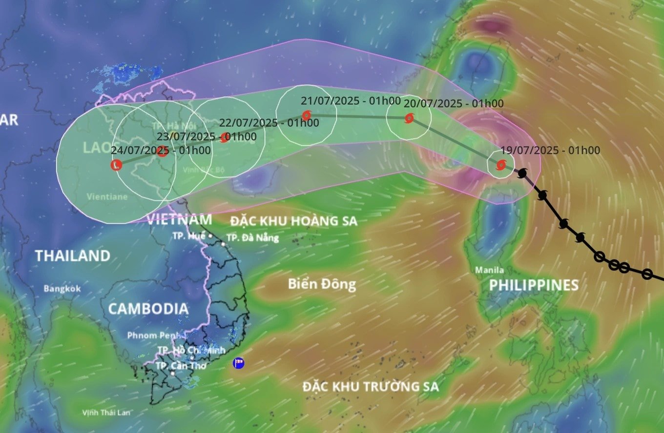
Forecast in the next 24 hours, storm Wipha is likely to strengthen again
At 7:00 p.m. on July 20, the center of storm No. 3 was located in the northwest sea area of the northern East Sea, about 480 km east of Quang Ninh - Hai Phong . The strongest wind near the center of the storm reached level 11 (103-117 km/h), gusting to level 14. The storm moved west at a speed of about 20 km/h, down one level compared to three hours earlier.
In the next 24 hours, the storm is forecast to intensify, moving west-southwest at a speed of 20-25 km/h. By 7:00 p.m. on July 21, the storm's center will be in the northern part of the Gulf of Tonkin, with winds near the center reaching level 11-12, gusting to level 15. The dangerous area at sea is determined north of latitude 19 degrees, from longitude 106.5 to 114 degrees east. The disaster risk level is level 3.
It is forecasted that by 7 p.m. on July 22, the storm will approach the coast of Hai Phong - Thanh Hoa provinces with winds of level 9-10, gusting to level 12. Within the next 72 hours, the storm will move west-southwest at a speed of 10-15 km/h, gradually weakening into a low pressure area as it moves deep into upper Laos.
At 7:00 p.m. on July 23, the low pressure area was located at about 19.7 degrees north latitude; 103.6 degrees east longitude, with winds below level 6.
Rough seas, strong winds level 15, unsafe for boats
Due to the storm's influence, the northwestern sea area of the northern East Sea has strong winds of level 8-9, near the storm's eye level 10-11, gusting to level 14. Waves are 5-7 m high, the sea is very rough. The northern Gulf of Tonkin (including Bach Long Vi, Co To, Cat Hai, Hon Dau) has winds gradually increasing to level 6-7, then to level 8-9, near the storm's eye level 10-12, gusting to level 15, waves are 3-5 m high. The southern Gulf of Tonkin (including Hon Ngu island) also has winds of level 6-7, near the storm's eye level 8-9, gusting to level 11.
The weather at sea and the oceanographic conditions are particularly dangerous, making it unsafe for all maritime activities, including cruise ships, passenger ships and cargo ships. There is a high risk of capsizing boats, damaging aquaculture cages and threatening the lives of fishermen if they do not get to a safe shelter in time.
Coastal areas of Quang Ninh - Hai Phong may be flooded due to rising water levels.
In coastal areas from Hai Phong to Quang Ninh, storm surges could reach 0.8 - 1.2 m. Specifically, the water level at Hon Dau (Hai Phong) is forecast to be 3.8 - 4.2 m, at Cua Ong (Quang Ninh) 4.8 - 5.2 m and Tra Co (Quang Ninh) 3.8 - 4.4 m. There is a high risk of flooding in coastal areas and river mouths, especially at noon and in the afternoon of July 22.
Strong winds on land, landslide and flooding warnings
From the evening and night of July 21, coastal provinces from Quang Ninh to Nghe An will have winds gradually increasing to level 7-9, near the storm center level 10-11, gusting to level 14. Further inland, winds of level 6-7, gusting to level 8-9 will also be recorded. Strong winds can cause trees, electric poles, roofs to fall and cause serious damage.
Regarding heavy rain, from July 21 to 23, the Northeast, the Northern Delta, Thanh Hoa and Nghe An will have heavy to very heavy rain, with rainfall ranging from 200-350 mm, with some places over 600 mm. Other places in the North and Ha Tinh will have rain ranging from 100-200 mm, with some places over 300 mm. There is a high risk of flash floods, landslides in mountainous areas and flooding in low-lying areas. Rain can reach a high intensity of over 150 mm in just 3 hours.
Source: https://baonghean.vn/bao-so-3-wipha-trong-24-gio-toi-giat-cap-14-sap-vao-vinh-bac-bo-canh-bao-mua-lon-va-gio-manh-khap-bac-trung-bo-10302728.html


![[Photo] National Assembly Chairman Tran Thanh Man visits Vietnamese Heroic Mother Ta Thi Tran](https://vphoto.vietnam.vn/thumb/1200x675/vietnam/resource/IMAGE/2025/7/20/765c0bd057dd44ad83ab89fe0255b783)


Comment (0)