
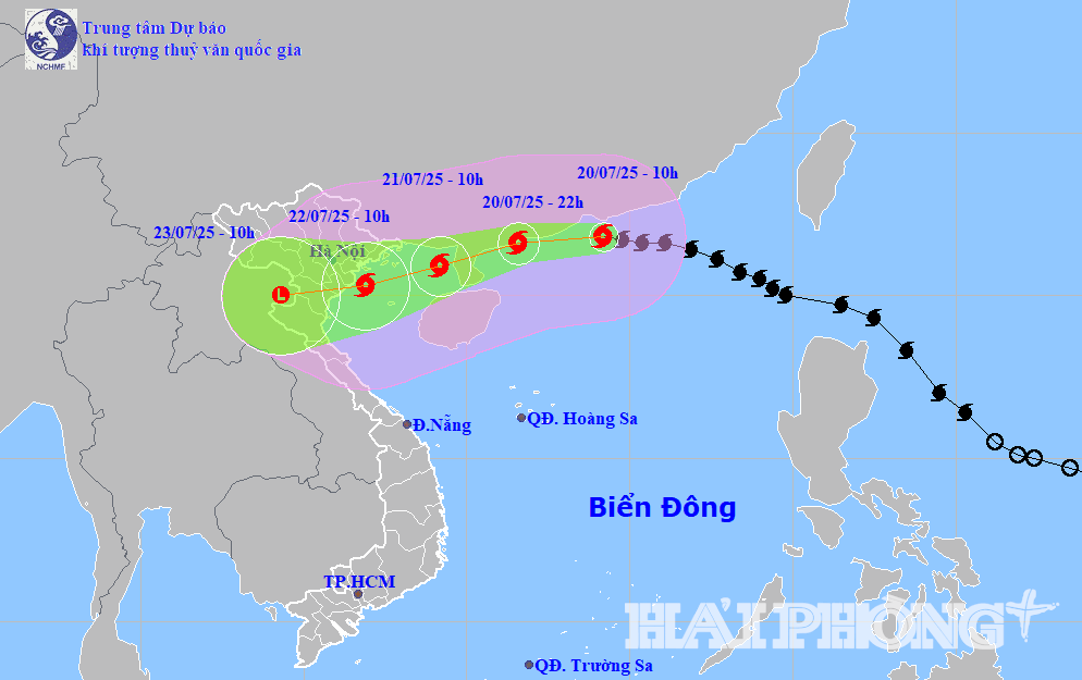
According to the National Center for Hydro-Meteorological Forecasting, at 10:00 a.m. on July 20, the center of storm No. 3 (storm WIPHA) was located at about 21.8 degrees north latitude, 114.2 degrees east longitude, in the northern sea area of the North East Sea, about 680 km east of Quang Ninh - Hai Phong . The strongest wind near the storm center is level 11 - 12 (103 - 133 km/h), gusting to level 15. Storm No. 3 is moving west at a speed of 20 - 25 km/h.
It is forecasted that in the next 24 - 72 hours, storm No. 3 will continue to move west, then turn west-southwest at a speed of 20 - 25 km/h. At 10:00 on July 21, the center of storm No. 3 is in the sea east of the northern Gulf of Tonkin. Winds near the center of the storm are at level 11, gusting to level 14. At 10:00 on July 22, the center of the storm will enter the coastal area from Quang Ninh - Thanh Hoa. The storm's wind intensity is at level 10 - 11, gusting to level 14.
Due to the influence of storm No. 3, the northern East Sea has strong storm winds of level 8-10, near the storm center of level 11-12, gusting to level 15; waves 5-7m high, rough seas.
From the night of July 20, the northern Gulf of Tonkin (including Co To, Bach Long Vi, Cat Hai, Hon Dau) will have strong winds of level 6-7, then increasing to level 10-11, gusting to level 14; waves 2-5m high.
Hai Phong – Quang Ninh area, sea level rise due to storm from 0.5 – 1.0m, total water level from 4 – 5m. High risk of flooding in low-lying areas at noon on July 22.
From July 21 to 23, the Northeast region, the Northern Delta, Thanh Hoa, Nghe An will have very heavy rain of 200 - 350mm, locally over 600mm. Other places in the North, Ha Tinh will have rain of 100 - 200mm, locally over 300mm.
PVSource: https://baohaiphongplus.vn/bao-so-3-tien-nhanh-ve-phia-dat-lien-quang-ninh-thanh-hoa-gay-mua-rat-to-o-bac-bo-416803.html


![[Photo] National Assembly Chairman Tran Thanh Man visits Vietnamese Heroic Mother Ta Thi Tran](https://vphoto.vietnam.vn/thumb/1200x675/vietnam/resource/IMAGE/2025/7/20/765c0bd057dd44ad83ab89fe0255b783)


Comment (0)