.gif)
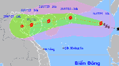
The strongest wind near the storm center is level 10 (89 - 102 km/h), gusting to level 12; moving west-northwest at a speed of about 20 km/h.
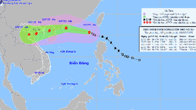
At 4:00 p.m. on July 20, storm No. 3 (storm WIPHA) moved west-northwest in the northern sea area of the North East Sea, about 370 km east of Leizhou Peninsula (China) at a speed of about 20 - 25 km/h and is likely to strengthen, with the strongest wind at level 11 - 12, gusting to level 15. The affected area is the northern sea area of the North East Sea. Disaster risk level 3.
As of 4 p.m. on July 21, the storm was moving mainly in a west-southwest direction, on the eastern sea area of the northern Gulf of Tonkin at a speed of about 15-20 km/h. The strongest wind speed was level 10-11, gusting to level 13. The affected area was the northern sea area of the northern East Sea, the eastern sea area of the Gulf of Tonkin. Disaster risk level 3.
By 4 p.m. on July 22, the storm was moving west-southwest over the mainland of the Northern Delta and Thanh Hoa at a speed of about 10-15 km/h and gradually weakening. The strongest wind was level 8, gusting to level 10. The affected area was the Gulf of Tonkin. Disaster risk level 3.
From the next 72 to 96 hours, the storm will continue to move mainly in the west-southwest direction, traveling about 5 - 10 km/h per hour and continue to weaken further.
Due to the influence of the storm, the northern sea area of the North East Sea has strong winds of level 8 - 10, near the eye of the storm it is level 11 - 12, gusts of level 15, waves 4 - 6 m high, and rough seas. From July 21, the northern sea area of the Gulf of Tonkin has gradually increased winds to level 6 - 7, then increased to level 8 - 9, near the eye of the storm it is level 10 - 11, gusts of level 13; waves 2 - 4 m high, near the eye 3 - 5 m, rough seas.
According to the assessment of the professional agency, the scope of influence of storm No. 3 is very wide, almost the entire northeastern region, some places in the western north, the North Central provinces and directly affects the Hai Phong area.
It is forecasted that on July 20-21, the special zones of Bach Long Vi, Co To, Cat Hai... are likely to be affected by strong winds and heavy rains due to storm No. 3.
Source: https://baohaiphongplus.vn/bao-so-3-dang-giat-cap-12-o-bac-bien-dong-va-co-kha-nang-manh-them-416751.html




![[Video] The difference in scores between university admission groups will be announced soon](https://vphoto.vietnam.vn/thumb/1200x675/vietnam/resource/IMAGE/2025/7/19/16441946784f4c4b8b6987f8164b1a83)
























Comment (0)