
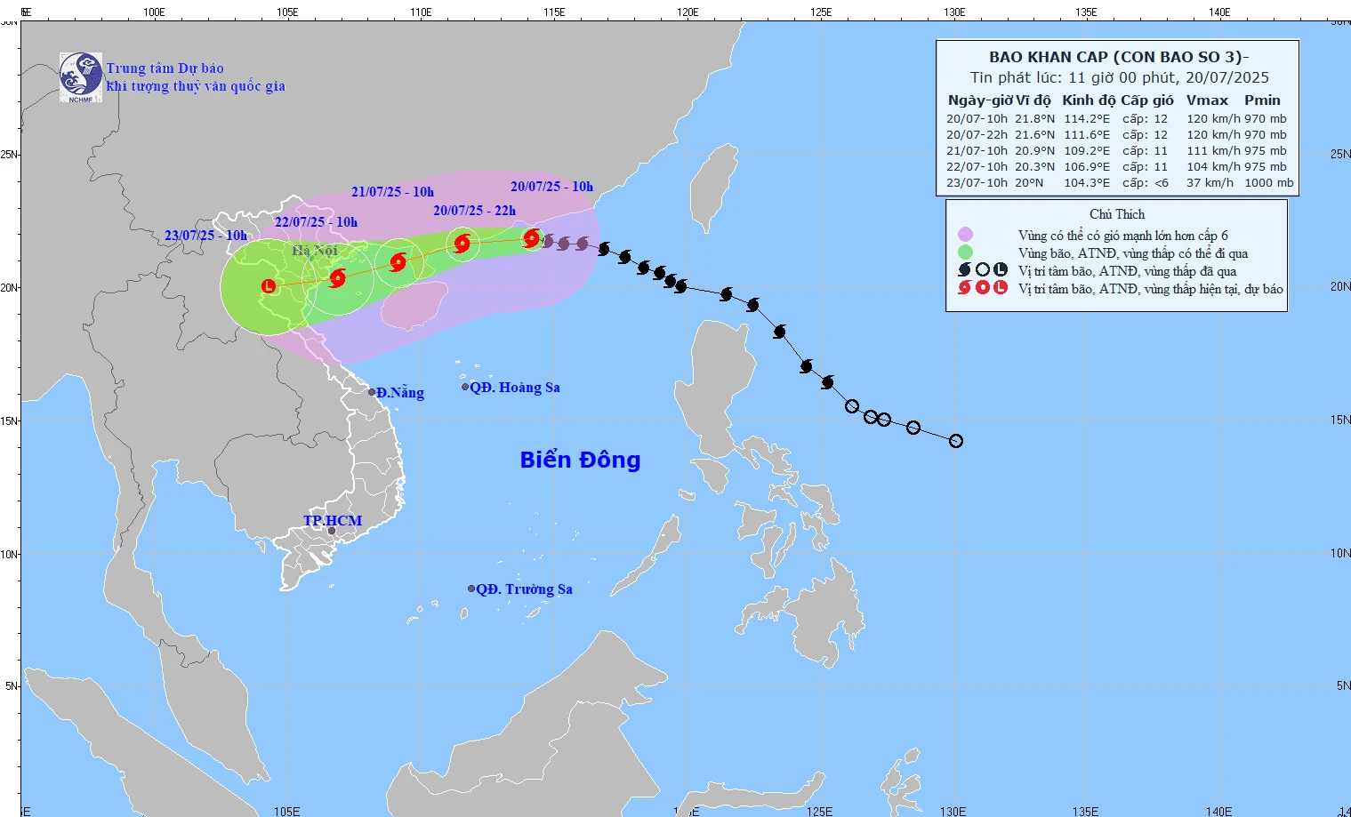
The storm will continue to move west, then turn west southwest at a speed of 20-25km/h.
Forecast of the storm's path in the coming days:
* 10:00 a.m. July 21: in the eastern sea area of the Northern Gulf of Tonkin, level 11, gust level 14.
* 10am July 22: Quang Ninh - Thanh Hoa coast, level 10-11, gust level 14.
* 10:00 a.m. July 23: on the mainland of Upper Laos, weakened into a low pressure, < level 6.
North of the North East Sea: wind level 8-10, near the storm center level 11-12, gust level 15; waves 5.0-7.0m high. Rough seas.
From the night of July 20:
Northern Gulf of Tonkin (Co To, Bach Long Vi, Cat Hai, Hon Dau): wind level 6–7, then increasing to level 10–11, gusting to level 14; waves 2.0–5.0m high.
Southern Bac Bo Gulf (Hon Ngu): wind level 6–7, near the storm center level 8–9, gust level 11; waves 2.0–4.0m high.
Vessels in the danger zone are at high risk of encountering thunderstorms, tornadoes, strong winds and large waves.
From July 21–23: Northeast, Northern Delta, Thanh Hoa, Nghe An very heavy rain 200–350mm, locally >600mm.
Elsewhere in the North, Ha Tinh has 100-200mm of rain, locally >300mm.
Warning of heavy rain >150mm in 3 hours at some locations.
NDS
Source: https://baothanhhoa.vn/anh-huong-cua-bao-so-3-ven-bien-quang-ninh--thanh-hoa-gio-giat-cap-15-255420.htm


![[Photo] National Assembly Chairman Tran Thanh Man visits Vietnamese Heroic Mother Ta Thi Tran](https://vphoto.vietnam.vn/thumb/1200x675/vietnam/resource/IMAGE/2025/7/20/765c0bd057dd44ad83ab89fe0255b783)


Comment (0)